
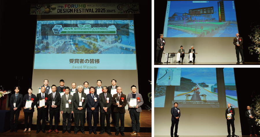
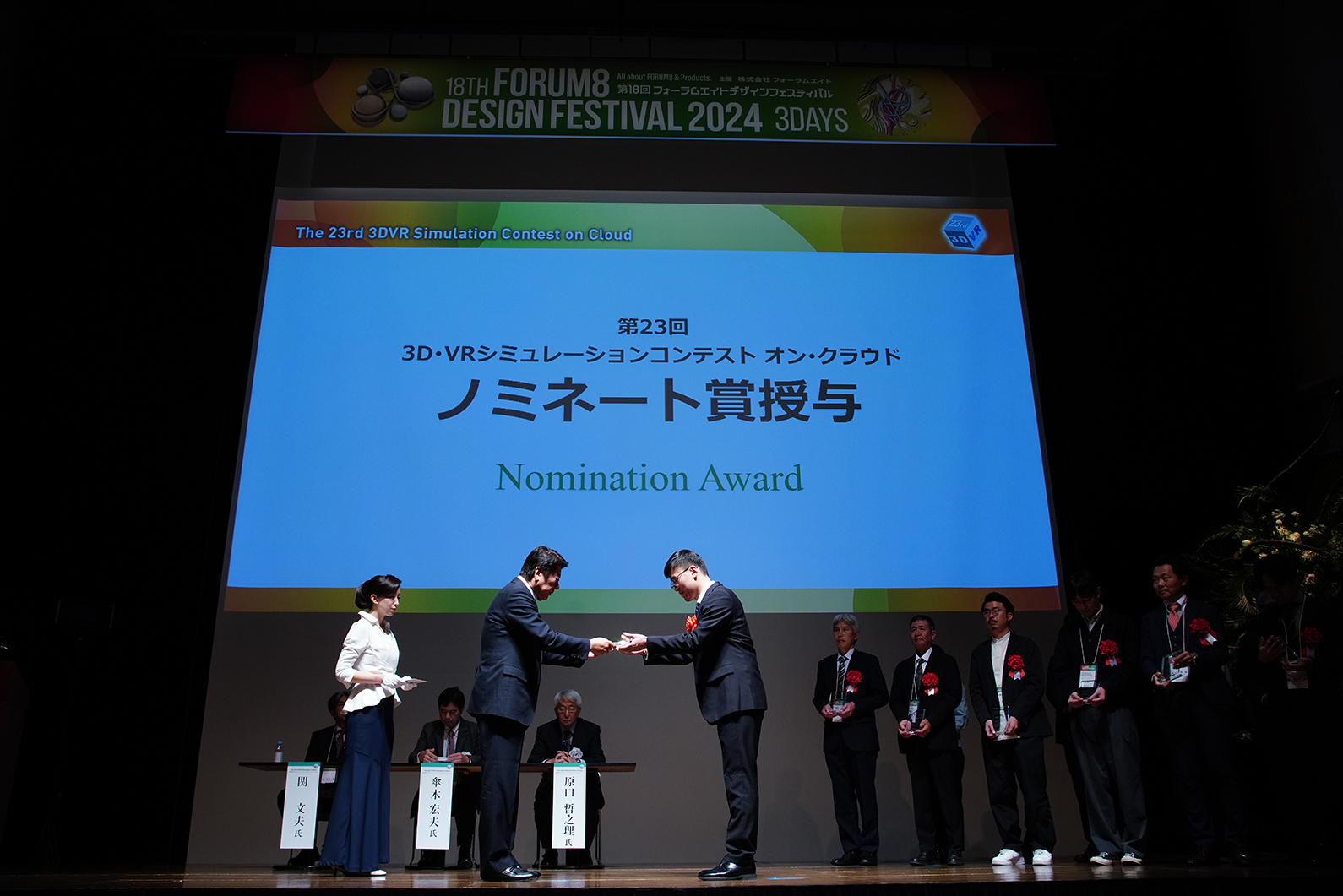
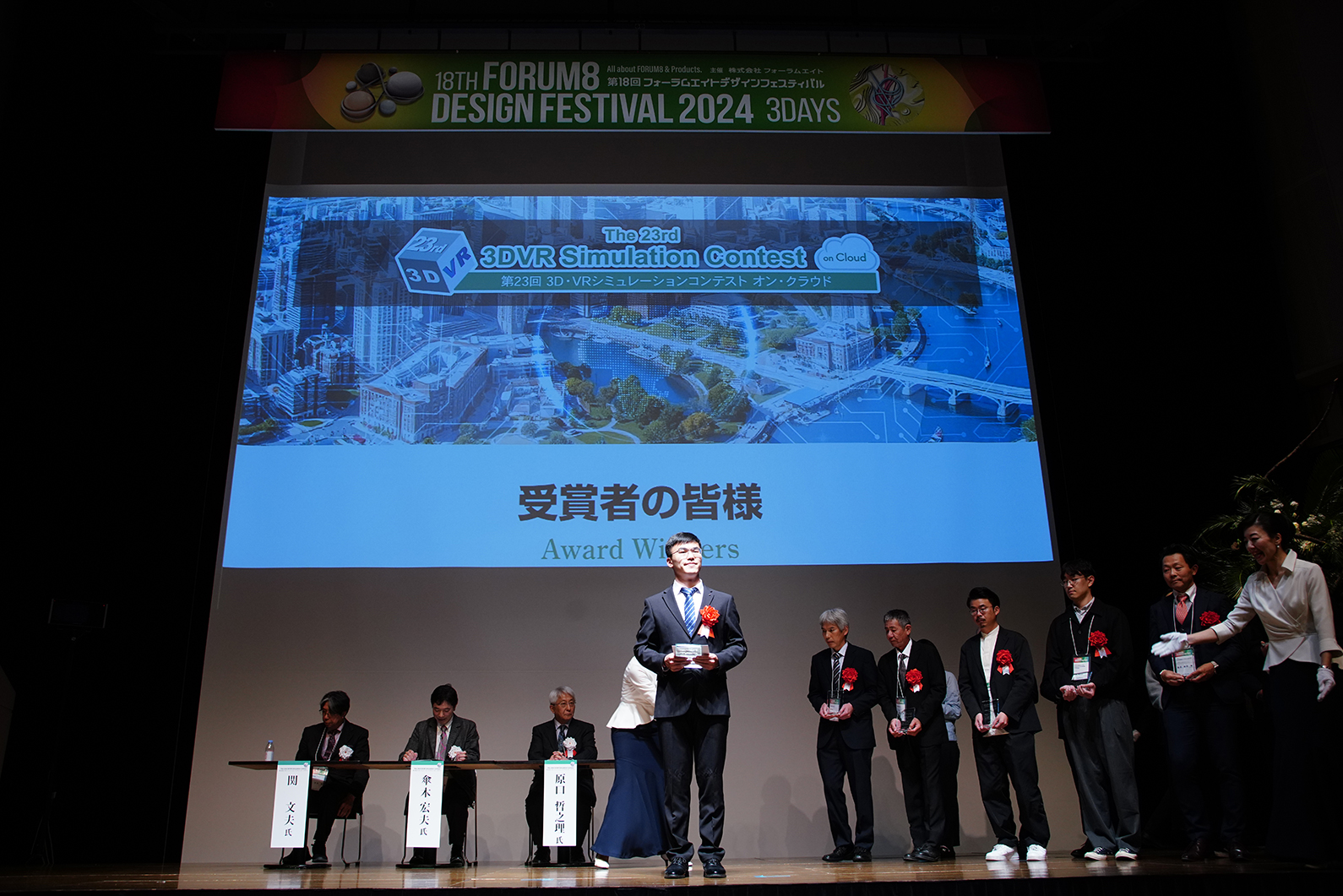
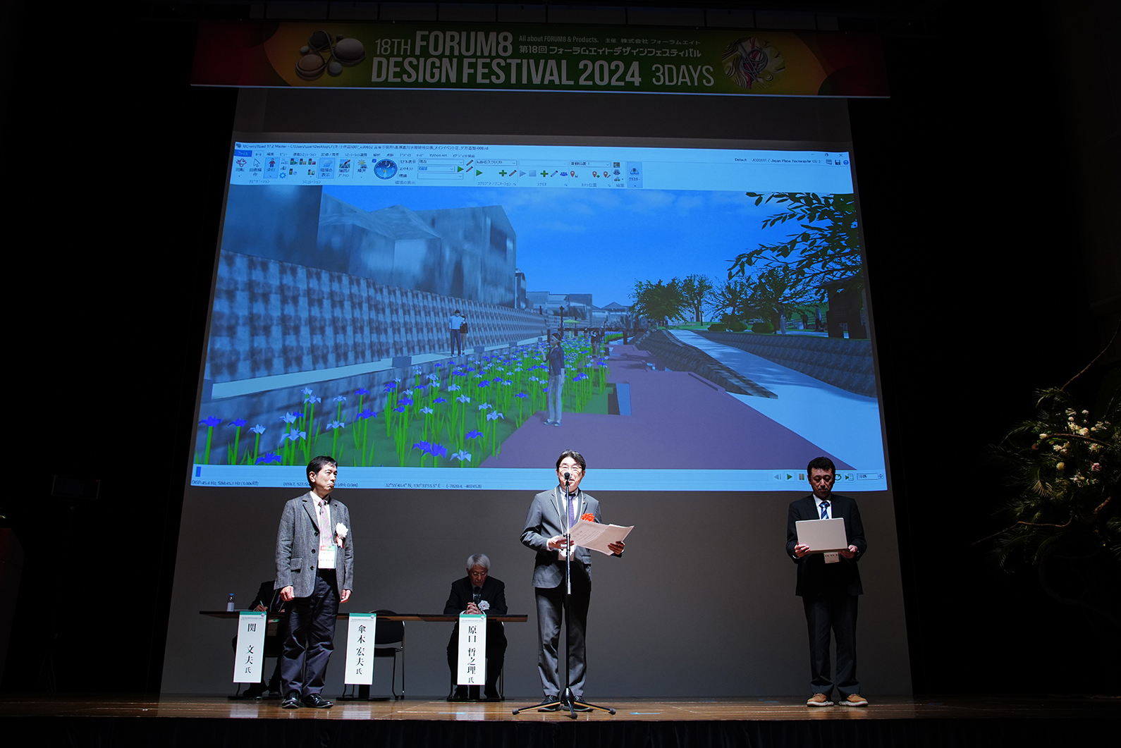
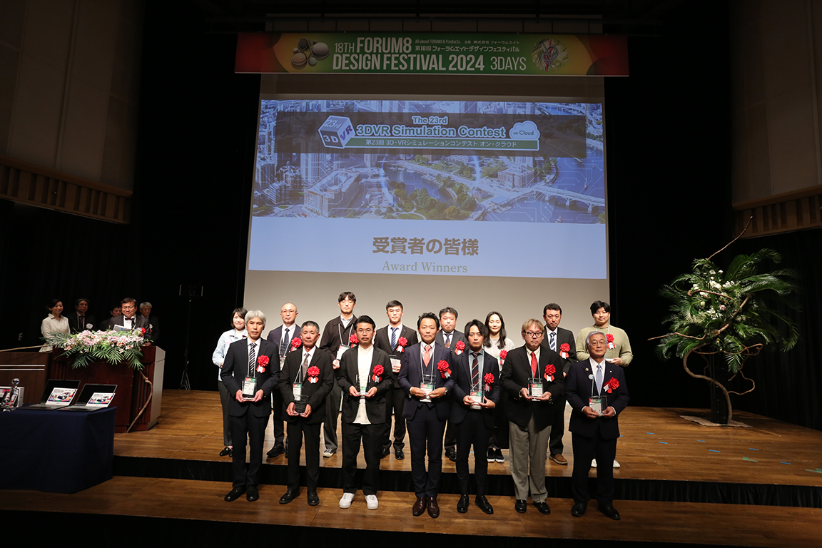
Results Announcement
After general voting and careful consideration by judges, Grand Prix, two 2nd Prize (Excellence Award), two Idea Award, Essence Award, three Honorable Judge Award, and VR SYSTEM OF THE YEAR have been decided. The Awards Ceremony was held at Shinagawa Intercity Hall on November 19th, 2025.
-
▲Awards Ceremony
(Nov. 19th 2025 at Shinagawa Intercity Hall) -
-
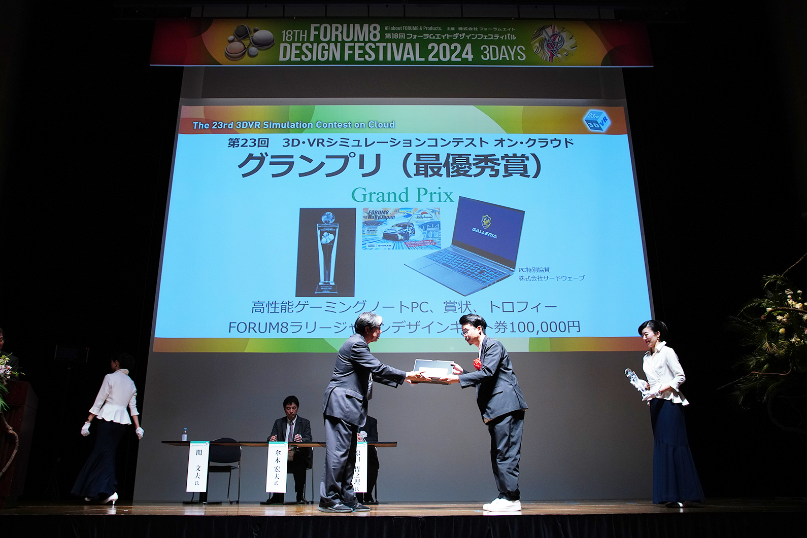
 Grand Prix (Highest Award)
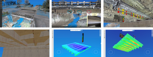
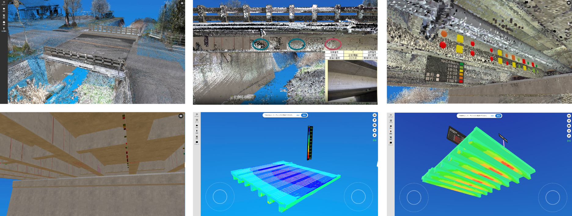
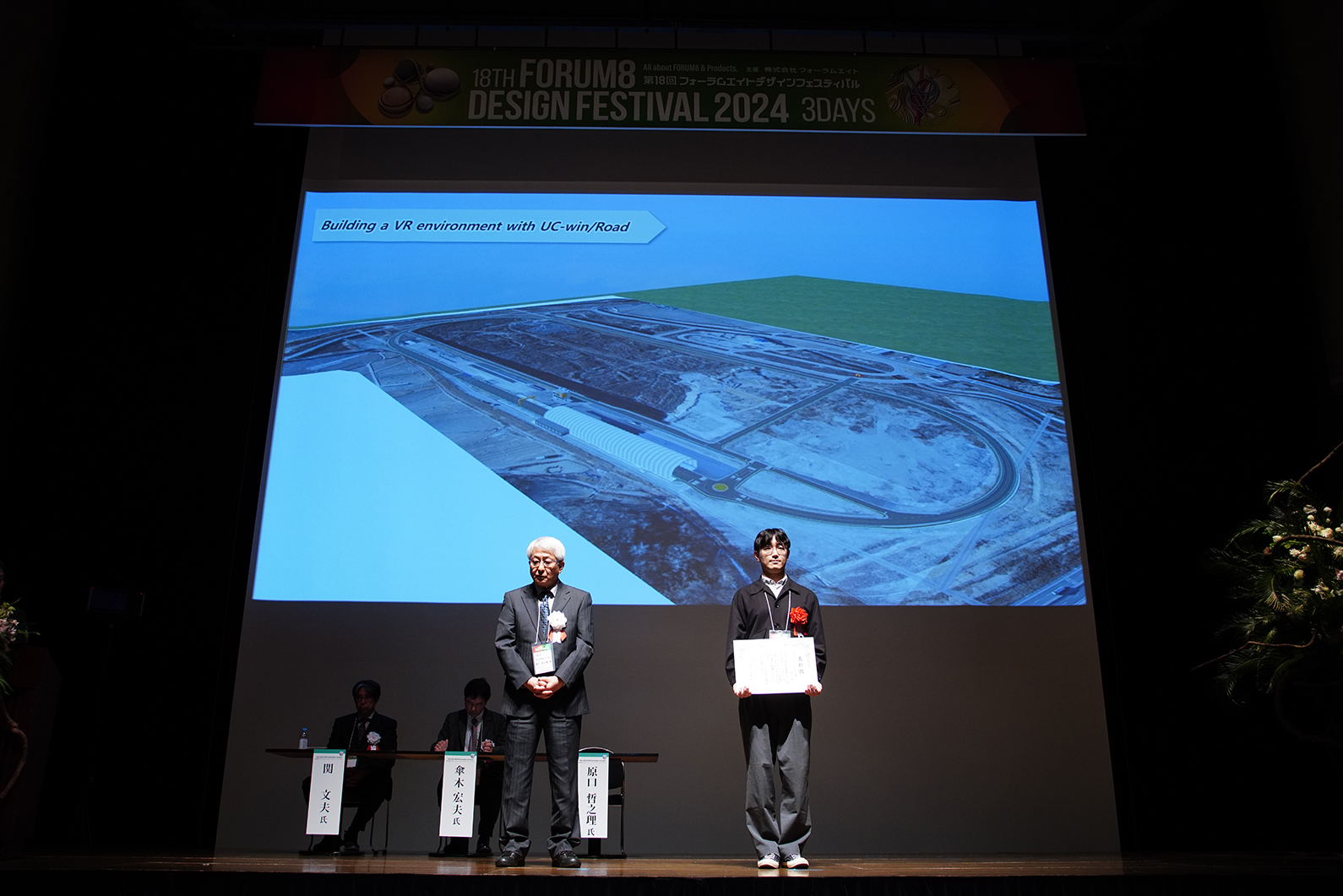
Ehime University
Metaverse Education Platform / IMSS (Infrastructure Maintenance Smart Simulator)
-
-
The Metaverse-based educational platform IMSS (Infrastructure Maintenance Smart Simulator) is a system designed for online learning that helps civil engineers develop infrastructure inspection skills. It incorporates features such as 3D point cloud data of RC bridges, BIM/CIM-based visualizations, and simulations of close-up visual inspections for damage and deterioration. In addition to its training capabilities, the platform accumulates a wide range of infrastructure data and also functions as an Infrastructure Museum.
-

-
2nd Prize (Excellent Award)
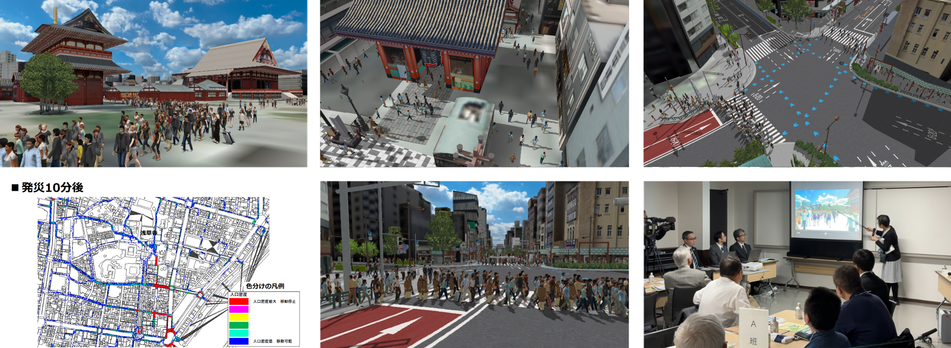
Taito-ku, Tokyo
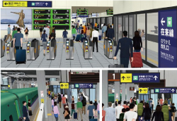
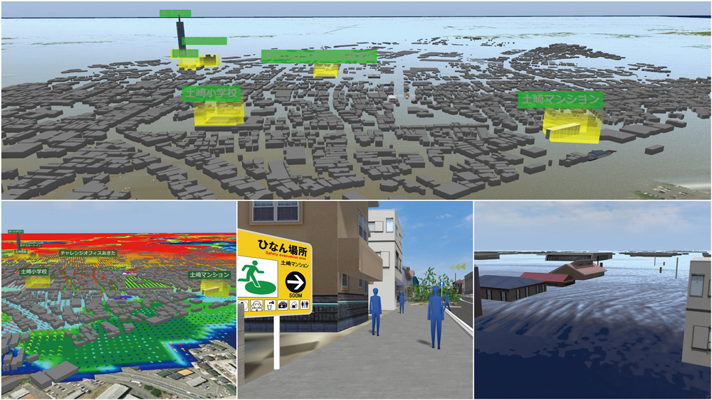
Simulation of initial evacuation for stranded people immediately after a large-scale disaster
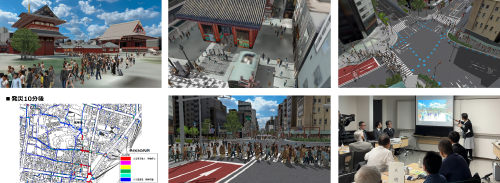 As a use case of the 3D city model based on the "Taito Ward Urban Development Guidance Policy," this work simulated stranded people in the Asakusa area during a disaster, visualizing areas where congestion is expected and verifying countermeasures. In addition, in cooperation with the Taito Ward Crisis and Countermeasures Division, this data is utilized as basic material for resident participation and planning.
 -
2nd Prize (Excellent Award)
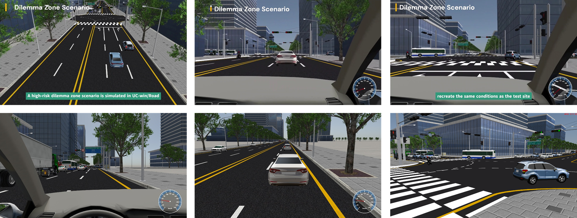
Advanced Institute of Convergence Technology
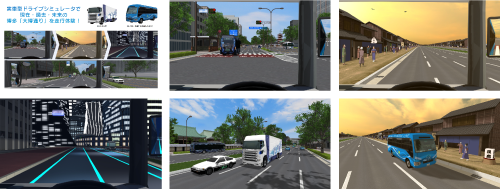
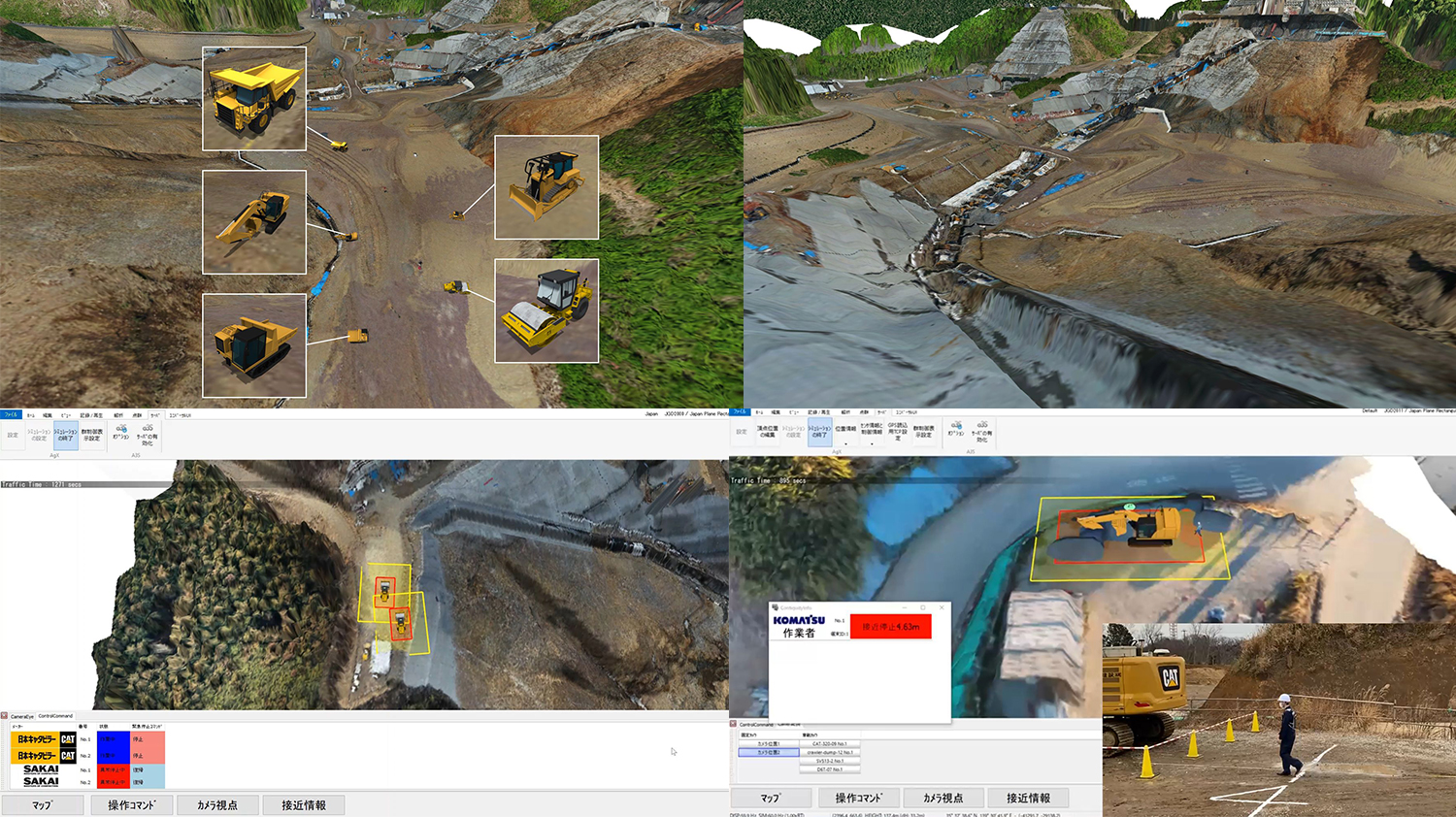
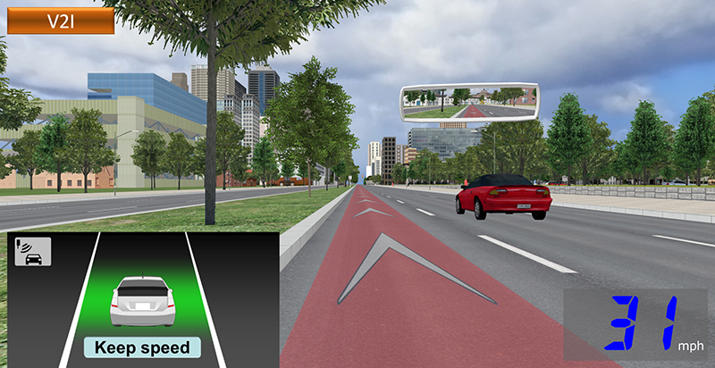
SILS for Real-time Risk Prediction Model Verification based on UC-win/Road
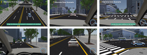 A Software-in-the-Loop Simulation (SILS) was developed to enable safe and efficient validation of autonomous driving algorithms and real-time risk prediction models. Through UC-win/Road’s real-time interface, data such as position, speed, acceleration, and brake signals are streamed to external prediction models, allowing real-time visualization of risk forecasts. By automating batch simulations and data collection, the system supports reproducible experiments and quantitative evaluations (e.g., scenario coverage and risk scoring accuracy).
The platform shifts initial validation to a virtual environment, reducing both cost and safety risks. It accelerates algorithm iterations while providing a reproducible workflow for testing autonomous driving and driver assistance functions within UC-win/Road. -
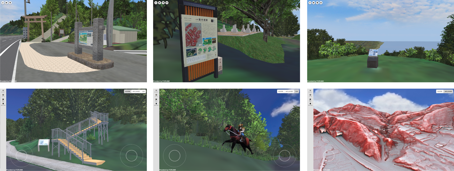
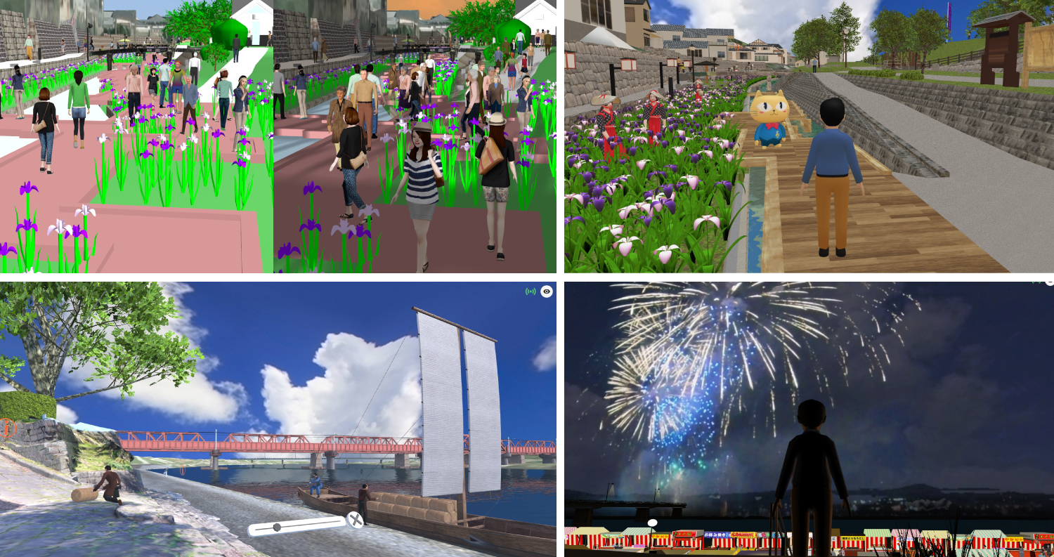
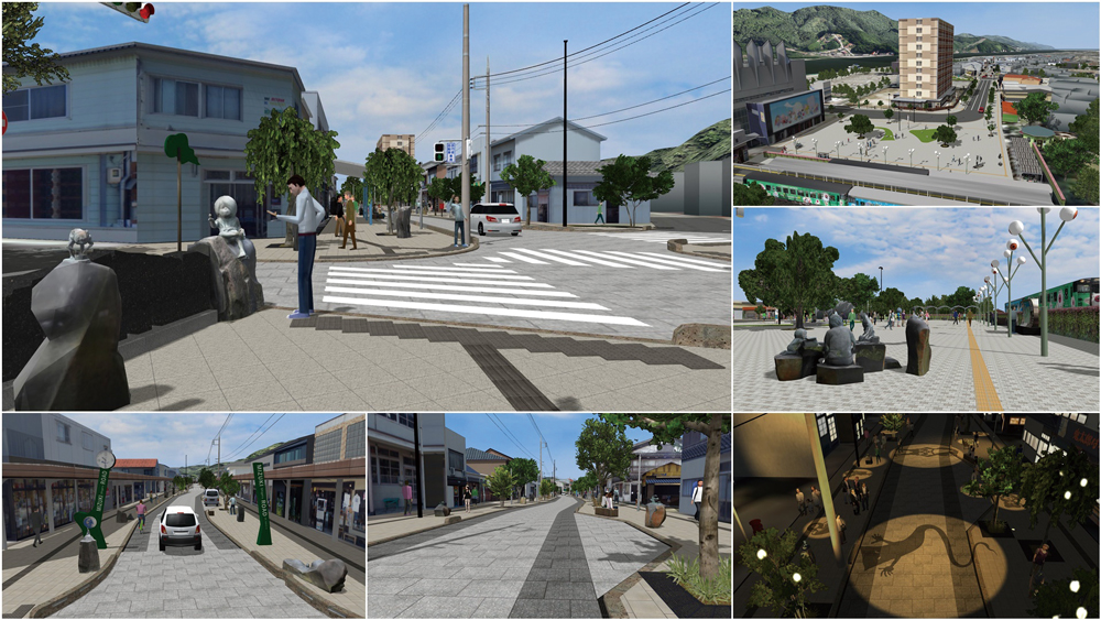
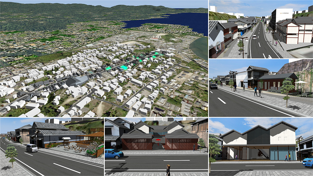
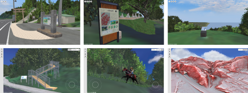 The landscape of the historic site of Wakimoto Castle ruins and 3D images of the red relief map that allows visitors to experience the terrain's contours have been recreated in the metaverse. In the data, you can see the castle entrance at the foot of the mountain, the Tenka-do road that was once a common route, the Uchidate area, and other scenery. In addition, you can also use the on-site QR code and AR function to experience scenes of mounted warriors galloping along the Tenka-do road and superimposed red 3D terrain.
 -
 Idea Award
Mitsui Consultants Co., Ltd.
'ChatGPT × UC-win/Road' - Proposing the use of AI in urban planning from a human-centered design perspective -
 Traditionally, urban landscapes have been determined qualitatively by experts, and quantitative consideration that reflects the opinions of the public is important in discussions of public spaces. Therefore, this project suggested a method to quantitatively generate urban landscape images using ChatGPT based on the results of an internet survey of 3,000 Japanese citizens nationwide and visualize them on UC-win/Road. This method was reported in an AI paper by the Japan Society of Civil Engineers.
 -
Essence Award
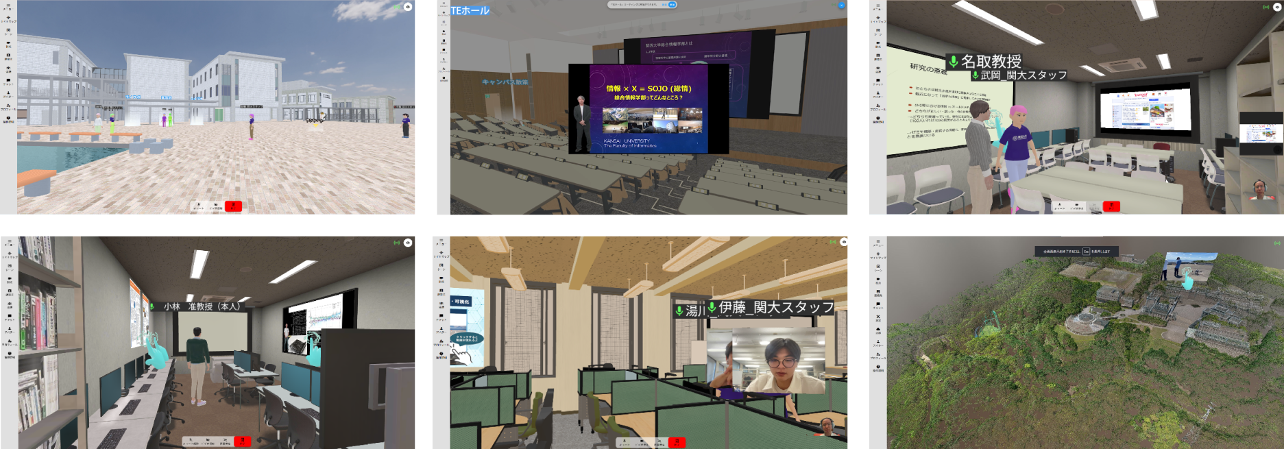
Faculty of INFORMATICS, Kansai University
Metaverse Open Campus / Faculty of INFORMATICS, Kansai University
 A Metaverse was created to hold an online open campus event for high school students. Aiming to enhance the experience of "school spirit and atmosphere," various facilities of different sizes on the Takatsuki campus were reproduced. Teacher avatars were created realistically from photographs, allowing teachers to hold real-time consultations with participating high school students using their own avatars. It is also possible to display a large-scale point cloud of the entire campus.
 -
Honorable Judge Award Design Award (Prof. Fumio Seki)
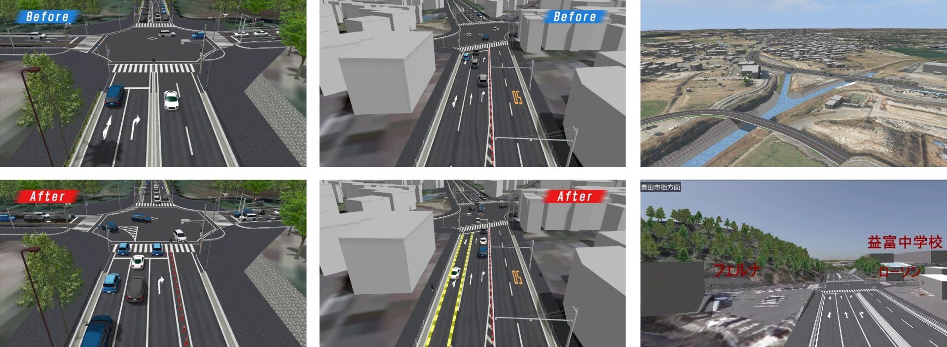
Toyota City, Aichi Prefecture
Future city planning using digital twins
 Using 3D city models and 3D point cloud data, future plans for road and river development, as well as traffic safety measures, are visualized to support explanations to residents and landowners. Additionally, traffic signal adjustments based on simulations help alleviate congestion.
Furthermore, initiatives are in place to engage the next generation by offering opportunities such as workplace experiences, where VR simulation activities are used to spark interest in municipal governance and the construction industry. -
Honorable Judge Award Community Development Award (Mr. Hiroo Kasagi)
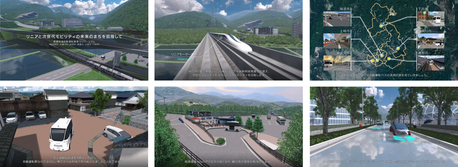
Ena City, Gifu Prefecture
Image of a next-generation mobility city in the Tono region
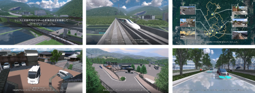 This is a promotional video that shows the image of the autonomous buses that are planned to operate in six cities in the Tono region. The video explains the bus routes and user groups expected for each region after the Linear Chuo Shinkansen opens, and shows how the buses will operate in actual locations. It also shows what the Tono region will look like in the near future, as a smart city utilizing next-generation mobility.
 -
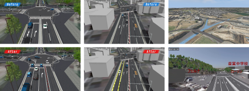
Honorable Judge Award Traffic simulation Award (Prof. Tetsunori Haraguchi)
Oriental Consultants Co., LTD.
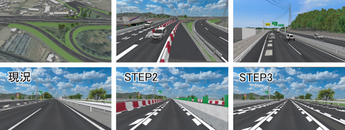
Examination on Road Improvements through Real-Time Linkage of Microscopic Traffic Simulation with DS
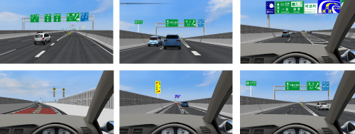 To evaluate improvements in road structures, road surface markings, and guide signs around junctions on urban expressways, a policy assessment experiment was conducted through real-time linkage of microscopic traffic simulation (FAMS) with a driving simulator (DS). Up to now, DS experiments faced a limitation where subjects could only be absolutely evaluated based on their first scenario run. This method overcomes that issue by generating diverse traffic flows through microscopic simulation, allowing absolute evaluation across multiple runs by a single subject. Driving experiment logs were used to assess lane change positions and instances of sudden deceleration.
 -
Noination Award
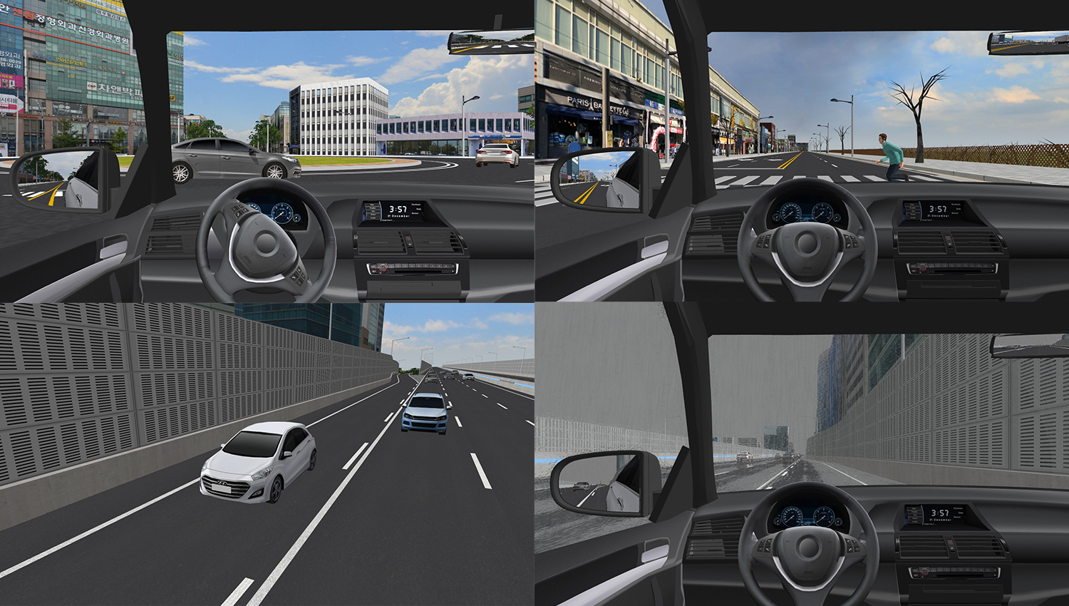
University of Seoul
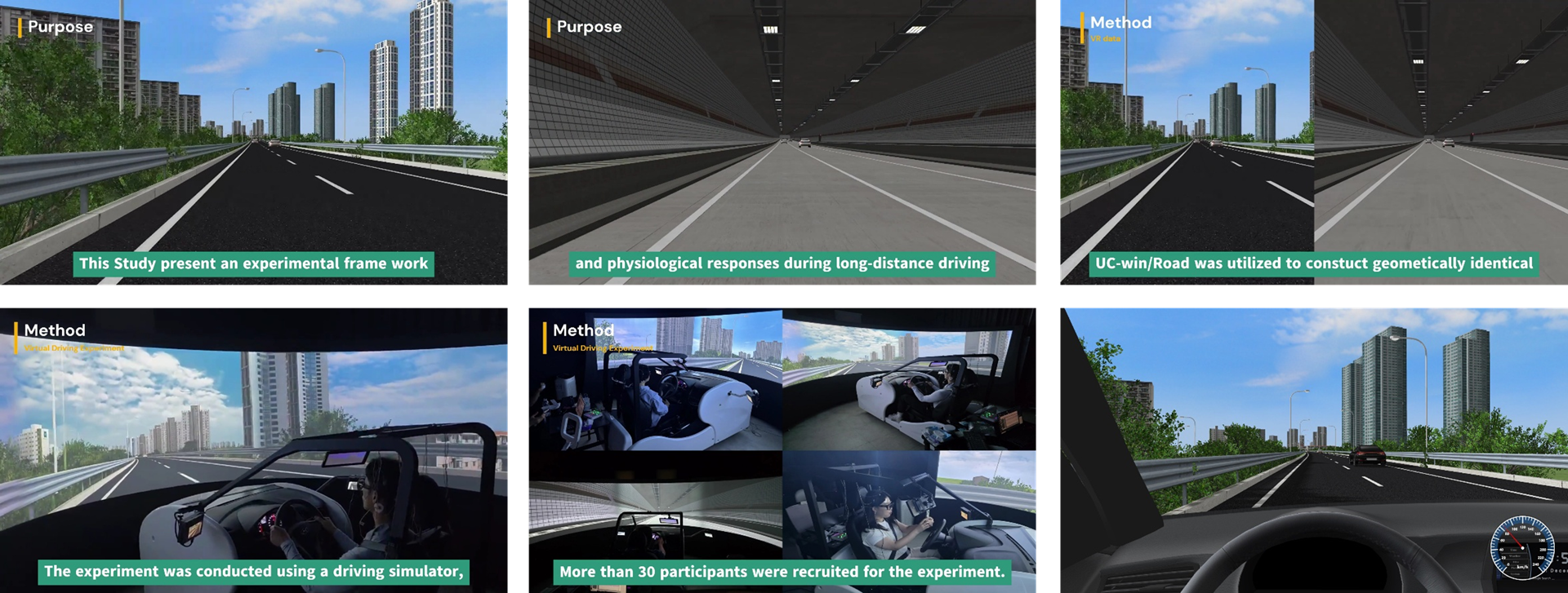
Comparative analysis of driver behavior and physiological responses during long-distance driving on surface roads and underground roads
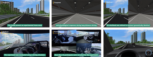 The research aims to provide insights into how driver performance and physical conditions vary over extended driving durations, informing design and safety countermeasures for upcoming underground expressways exceeding 20 km in South Korea. UC-win/Road was utilized to construct geometrically identical above-ground and underground scenarios, enabling controlled comparisons under both environments, and vehicle parameters—such as speed, acceleration, lateral deviation, steering angle, and brake pedal force—were automatically recorded during virtual driving using UC-win/Road as driver response logs, which were then analyzed. Visual behavior was recorded using Tobii Pro Glasses, capturing gaze distribution, pupil diameter, and blink frequency. The platform employed UC-win/Road’s Log Export and VR-based visualization functions for automated data acquisition and immersive scenario presentation. Through these capabilities, the system provides a safe, repeatable environment for assessing driver workload, stability, and physiological adaptation in long underground routes. The findings support the design and operation of future underground expressways by offering evidence-based insights into driver responses under extended enclosed driving conditions.
 -
Noination Award
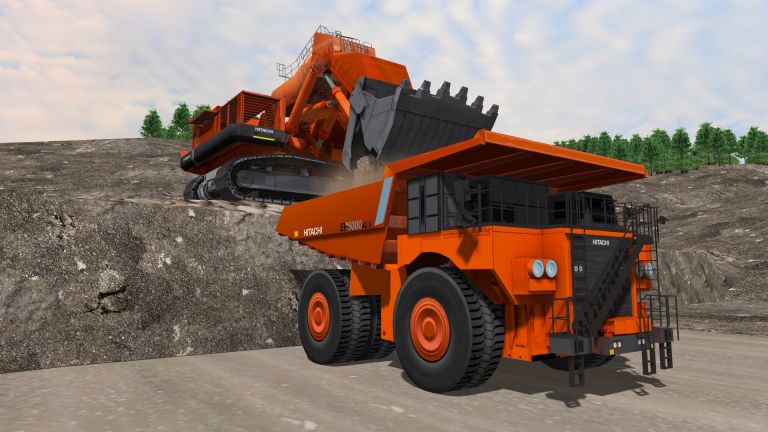
Northern Kyushu Green Advanced Automotive Industry Promotion Council
Hydrogen Vehicle Driving Experience Simulator
 As an experiential content themed around a hydrogen-based society, driving simulations of hydrogen buses and hydrogen trucks were developed. The simulation recreated the roads and scenery around Hakata Station, included scenes comparing hydrogen vehicles with diesel vehicles, and featured electric vehicles driving through landscapes from the Edo period. Toward the end, it depicted a futuristic vision of Fukuoka with advanced mobility technologies such as drones and ropeways. This experience was showcased at the Fukuoka Mobility Show 2023.
 -
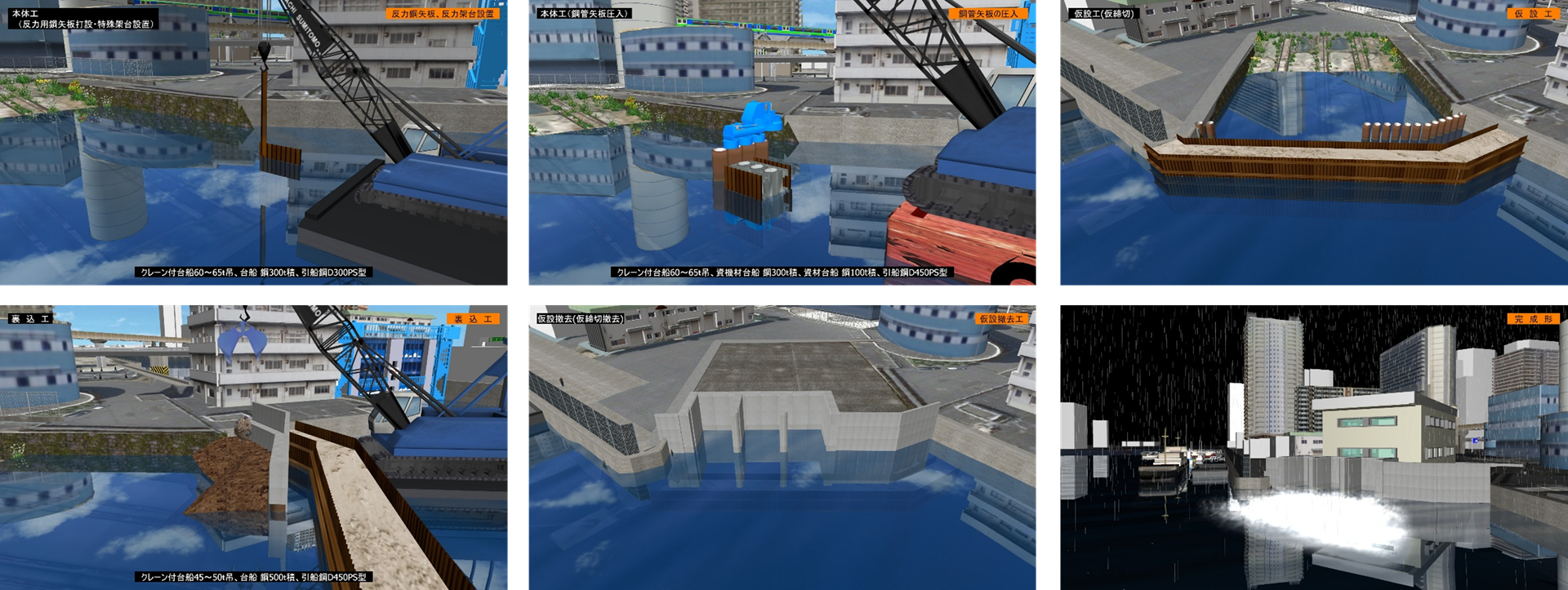
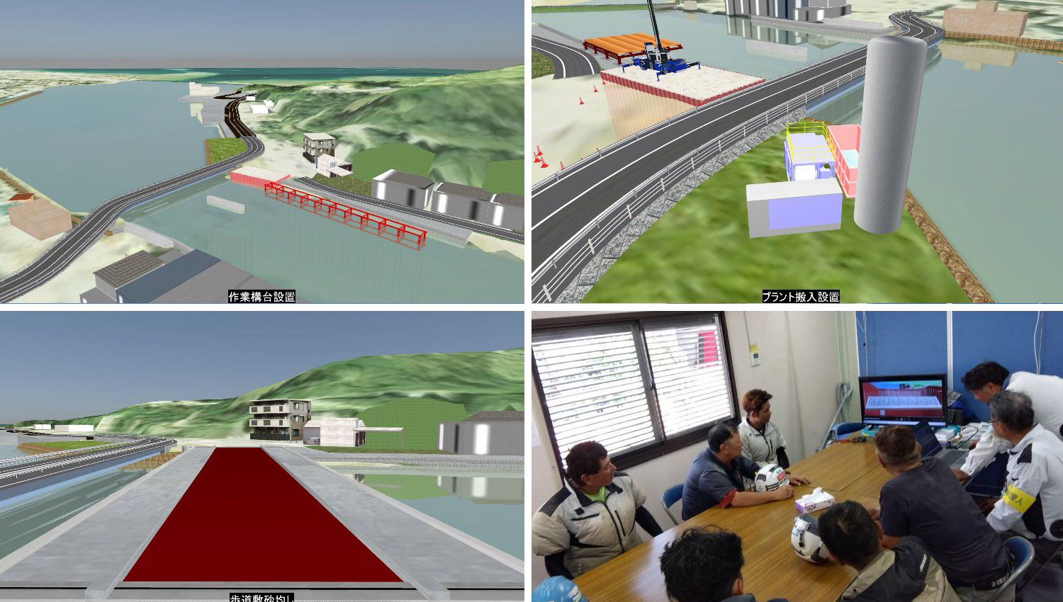
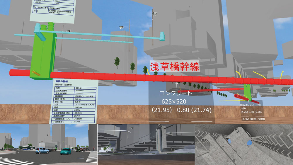
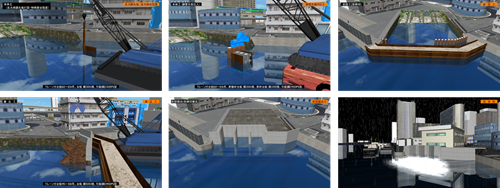 A new drainage pumping station was constructed together with the seawall, and its structure protects the station from flooding during high tides. The entire construction plan and procedures were reproduced using 3D VR simulation, allowing for confirmation of safety and progress during construction and efficient information sharing among related organizations.
 -
Noination Award
CREATIVE LAB Co., Ltd.
Hanwa Expressway renovation project - User-perspective traffic regulation simulation using digital twins
 This project recreated the renovation work on the Hanwa Expressway using a digital twin and visualized plans replacing bridges without closing them to traffic in VR. Unexpected congestion can be avoided and user safety can be verified in advance by simulating traffic flow and traffic from the driver's perspective in response to complex changes in restricted sections at each stage. A notable feature is the expansion of the scope of use beyond construction management.
 -
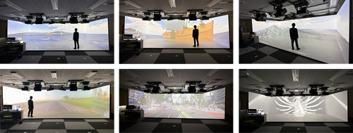 XR system that is 8m wide x 2.5m high, capable of large-scale projection using 8 projectors at the front, back, left, right, and on the floor, and is using UC-win/Road as its core platform. UC-win/Road supports the construction of a digital twin space, performing a variety of simulations, playing 360-degree videos, making 3D VR visuals of CT scan images in DICOM format, and more in a wide range of fields including traffic, environment, and medical care.


-
-

-
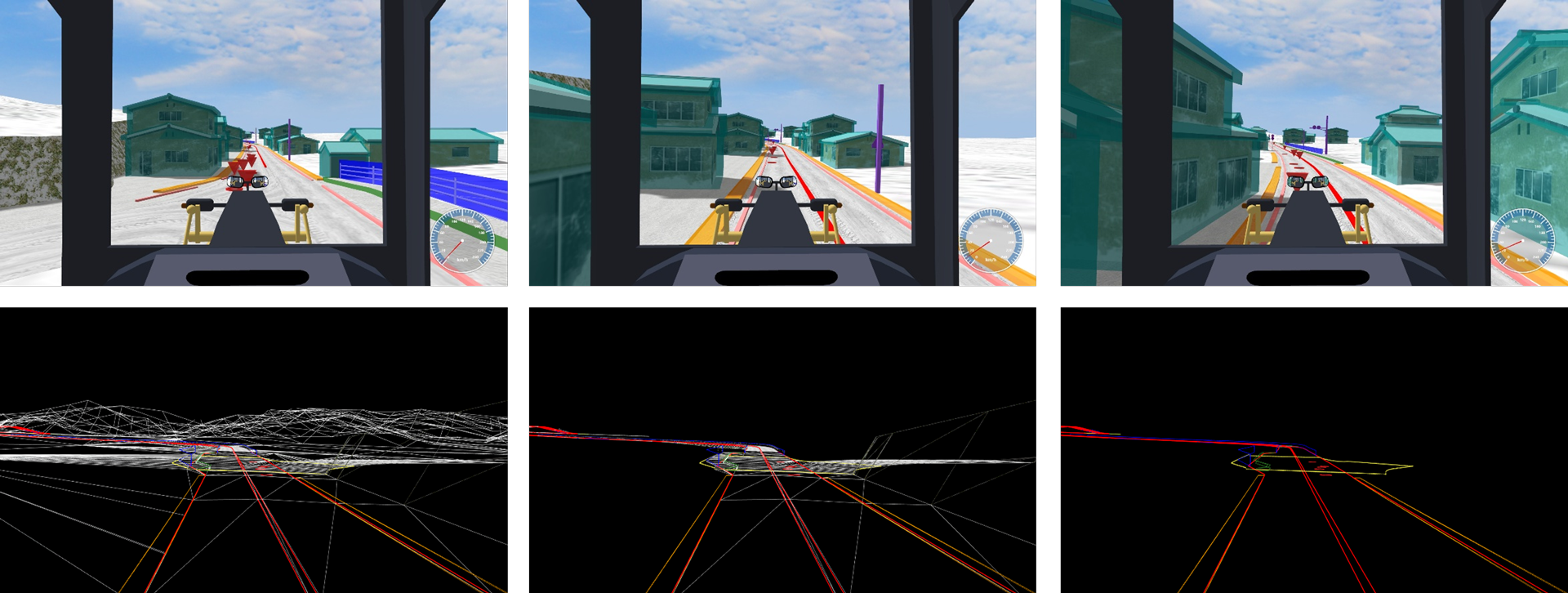
A 3D VR snow removal guidance system was developed by integrating position data obtained from an RTK-GNSS positioning system with UC-win/Road. Within the snowplow grader, a monitor displays VR imagery synchronized with the actual driving position. This enables real-time visual alerts near features such as manholes and bridge joints. The system also allows operators to visually confirm the positions of curbs and lane boundaries.
-
Overview of 3D VR Simulation Contest
3D/VR Simulation Contest on Cloud started with our VR Design Studio UC-win/Road software winning the "Software Product of the Year" award in 2002. The main event of the FORUM8 Design Festival, the contest is an annually held competition between contestants from around the world to see who can create the most advanced VR simulation using VR Design Studio UC-win/Road, and this year we will host our 24th contest. Public online voting via VR-Cloud® has been implemented since 2011, and on the metaverse using Metavania F8VPS in 2024, contributing to a greater success in our contest.
A new award "VR SYSTEM OF THE YEAR" was established in 2022.
Submission Requirements
UC-win/Road has been used in various fields from civil engineering/construction, to driving/traffic simulations, to even construction ICT, construction automation, environment, disaster countermeasures, education and training, and medical care. In particular, there have recently been some notable examples of XR, AI, sensing, etc.
We look forward to your applications for the state-of-the-art VR data and systems that accelerate smart cities and DX by making the most use of solutions provided by UC-win/Road and Metavania F8VPS to enable advanced communication through data.
Application / Schedule
- Submission Conditions
①Work data and 5-minute script
②Overview of data explaining contents and operation in a brief format
- Destination of Submission
Please tell your contact person of FORUM8 staff and send it to him/her.
- Schedule
-
-
- Fri. Oct. 17th, 2025
- Deadline for Application
- Wed. Oct. 22nd, 2025
- Nomination Work Screening
- Tue. Nov. 4th -
Thu. Nov. 13th, 2025 - General Voting Period
Tue. Nov. 18th, 2025
- Award winning selection
Wed. Nov. 19th, 2025
- Announcement and Award Ceremony
Venue: Shinagawa Intercity Hall
-
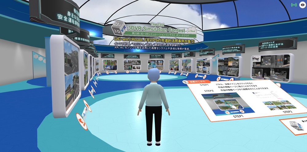
▲Metaverse voting venue using Metavania F8VPS (2024)
-
- Copyright of Submitted Work
The copyright of the VR data of the winning work belongs to the applicant.
Although the submitted data will not be distributed, FORUM8 will edit and process output images, videos, etc. for the data, works and deliverables produced by the author, and will make external presentations, research presentations, sales activities, As a public relations activity, you have a secondary license right such as publication/introduction on media such as HP, public relations magazines, books, magazines and newspapers.
- Inquiries for Application
TEL:03-6894-1888 FAX:03-6894-3888
E-mail:forum8@forum8.co.jp
Awards / Prizes
-

Grand Prix
High-performance gaming laptop GALLERIA RL7C-R55-5N, Shopping gift card designed with FORUM8 Rally Japan (JPY100,000), Trophy
-
2nd Prize (Excellent Award)
Gaming laptop GALLERIA RL7C-R35-5N, Shopping gift card designed with FORUM8 Rally Japan (JPY50,000)
-
Idea/Essence Award
Shade3D Game Programming PC, Shopping gift card designed with FORUM8 Rally Japan (JPY30,000)
-
Honorable Judge Award
iPad, Shopping gift card designed with FORUM8 Rally Japan (JPY30,000)
-
Nomination Award
Plaque, Shopping gift card designed with FORUM8 Rally Japan (JPY10,000)

VR SYSTEM OF THE YEAR*
Trophy, Shopping gift card designed with FORUM8 Rally Japan (JPY200,000)
Juries of 3DVR Simulation Contest
-

Jury Chief
Prof. Fumio Seki
Professor, Civil Eng. Dept.
Fac. of Science and Tech., Nihon UniversityAfter engaging in various designs such as bridge, tunnel, civil engineering, river, and road at a major construction company, he was appointed in the current position since 2011. In recent years, in addition to civil engineering design, he works on a wide range of digital technologies, PFI and PPP projects.
-

Mr. Hiroo Kasagi
Representative of NPO Community Development Studio
Director of Japan Society for Impact Assessment, director of Laboratory of Autonomy Problem, part-time instructor of University of Tsukuba, etc. Won the prize of Minister for the Environment for his activity of global warming in 2005. Author of some books.
-
Prof. Tetsunori Haraguchi
Visiting Prof., Org. for Future Society Creation, Nagoya University
After graduating from Department of Mechanical Engineering and Sciences, Graduate School of Kyoto University, he worked at Toyota Motor Corporation, and engaged in the vehicle dynamic performance development at the experiment field and the future vehicle planning at the planning field. Started to work at Nagoya University since 2011 and is a visiting professor now.
Juries of VR SYSTEM OF THE YEAR
-
Mr. Yuji Ito
Representative Director, VR Promotion Council / President and CEO, FORUM8 Co., Ltd.
-
Prof. Fumio Seki
Director, VR Promotion Council
Professor, Civil Engineering Dept. Faculty of Science and Tech., Nihon Univ. -
Mr. Ryuzo Aida
Director, VR Promotion Council
Chairman & CEO, Nihon Technos
* The VR Promotion Council, which judges the VR SYSTEM OF THE YEAR award, works to develop and provide a virtual platform using VR, as well as to utilize it in various industrial fields in collaboration with local governments and other organizations. FORUM8 cooperates with this council as a corporate member.
Past Award Winners
-
 23rd Grand Prix (Highest Award)
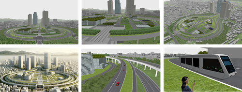
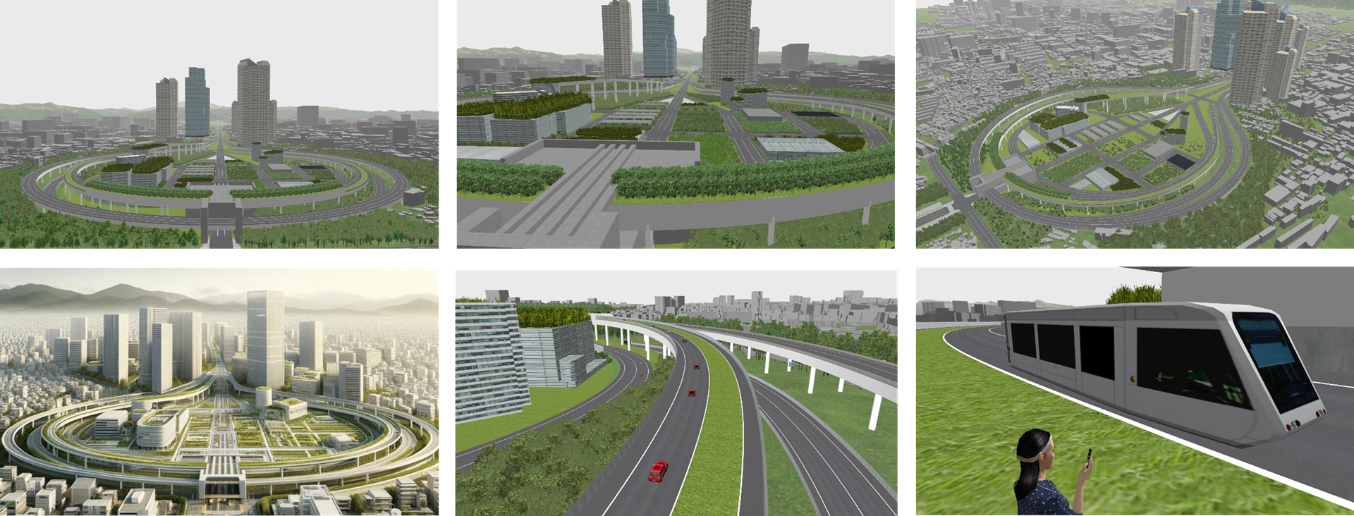
DX Platform for Umekita 2nd Phase District Urban Planning
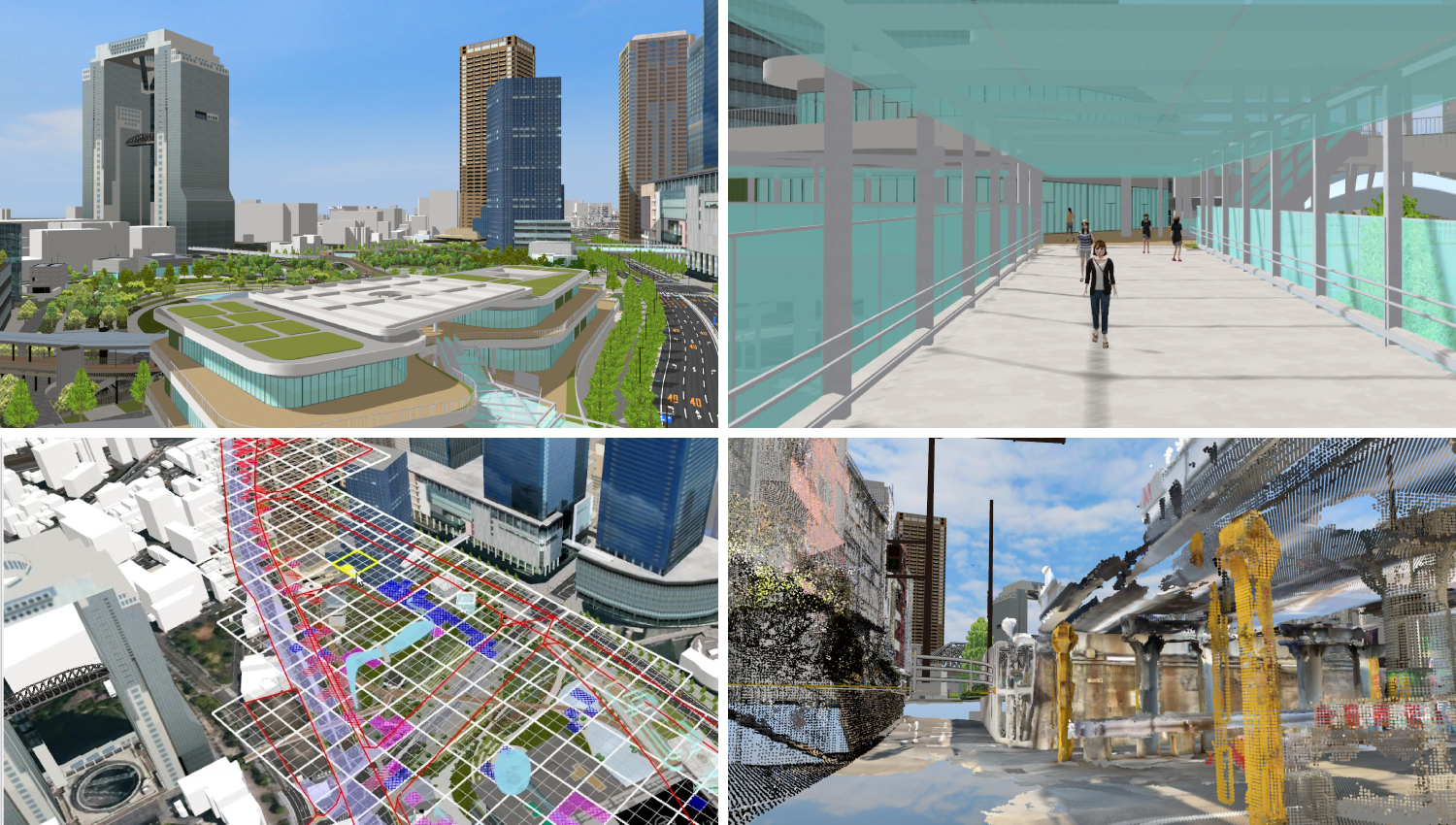 A 3D urban model that reproduces the completed “Umekita 2nd Phase District” is constructed in VR space for use in consensus building among stakeholders, as a study tool for smart city formation, and for improving productivity in design and construction. A wide range of use cases have been implemented, from allowing people to experience the Metaverse experience of the park area to the construction of a soil contamination information visualization system, making it possible to continue its use as a DX platform for urban development.
 -
23rd 2nd Prize (Excellence Award)
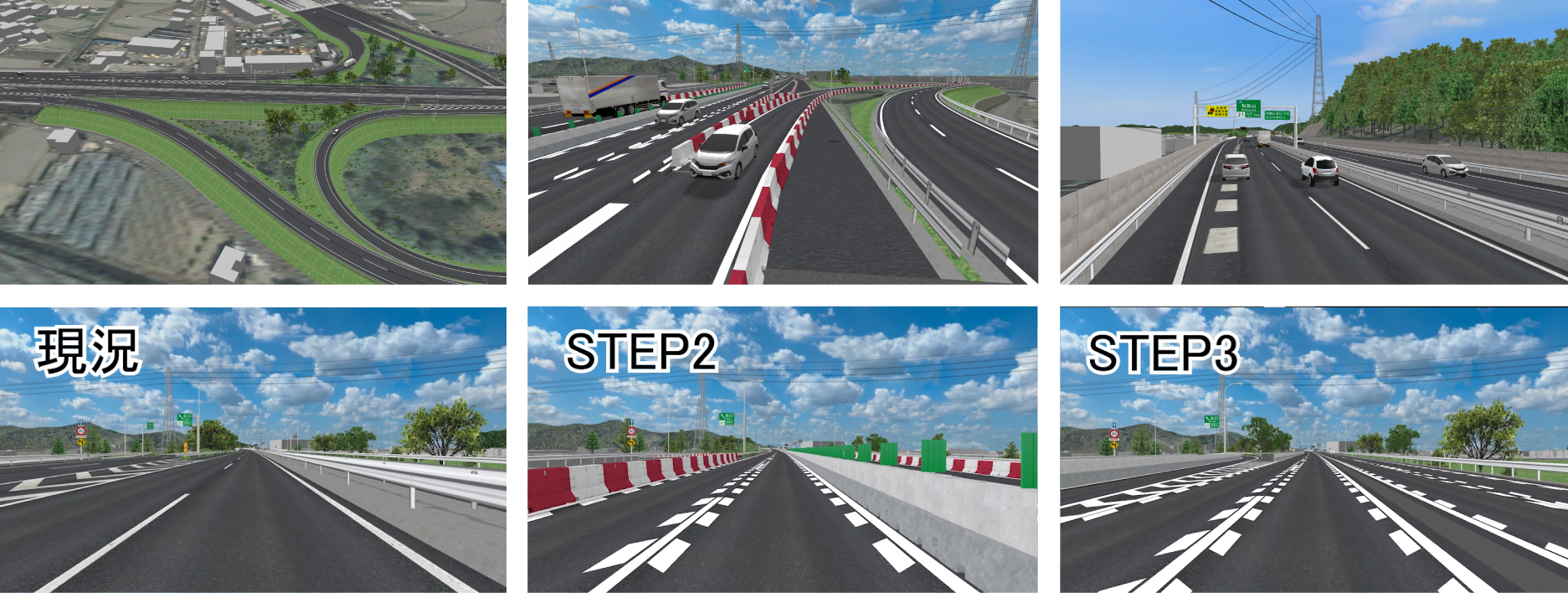
“Proposal for National Resilience using BIM/CIM” - Proposal for Ensuring Safe and Smooth Traffic Flow during Rainfall
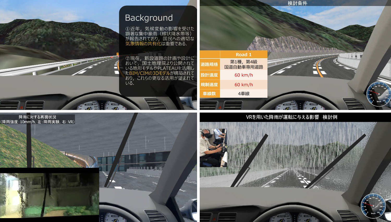 In recent years, there have been reports of damage caused by torrential rains, and it is important to share appropriate weather information. Therefore, we examined the effects of differences in environmental conditions such as rainfall on vehicle drivers through driving simulations that effectively utilize BIM/CIM models constructed during road design, and examined the effects on driving speed (operable speed) during future rainfall events.
 -
23rd 2nd Prize (Excellence Award)
Akishima Traffic Congestion Simulation Production Committee
Traffic and Landscape Simulation with Residents Participating in the Simulation
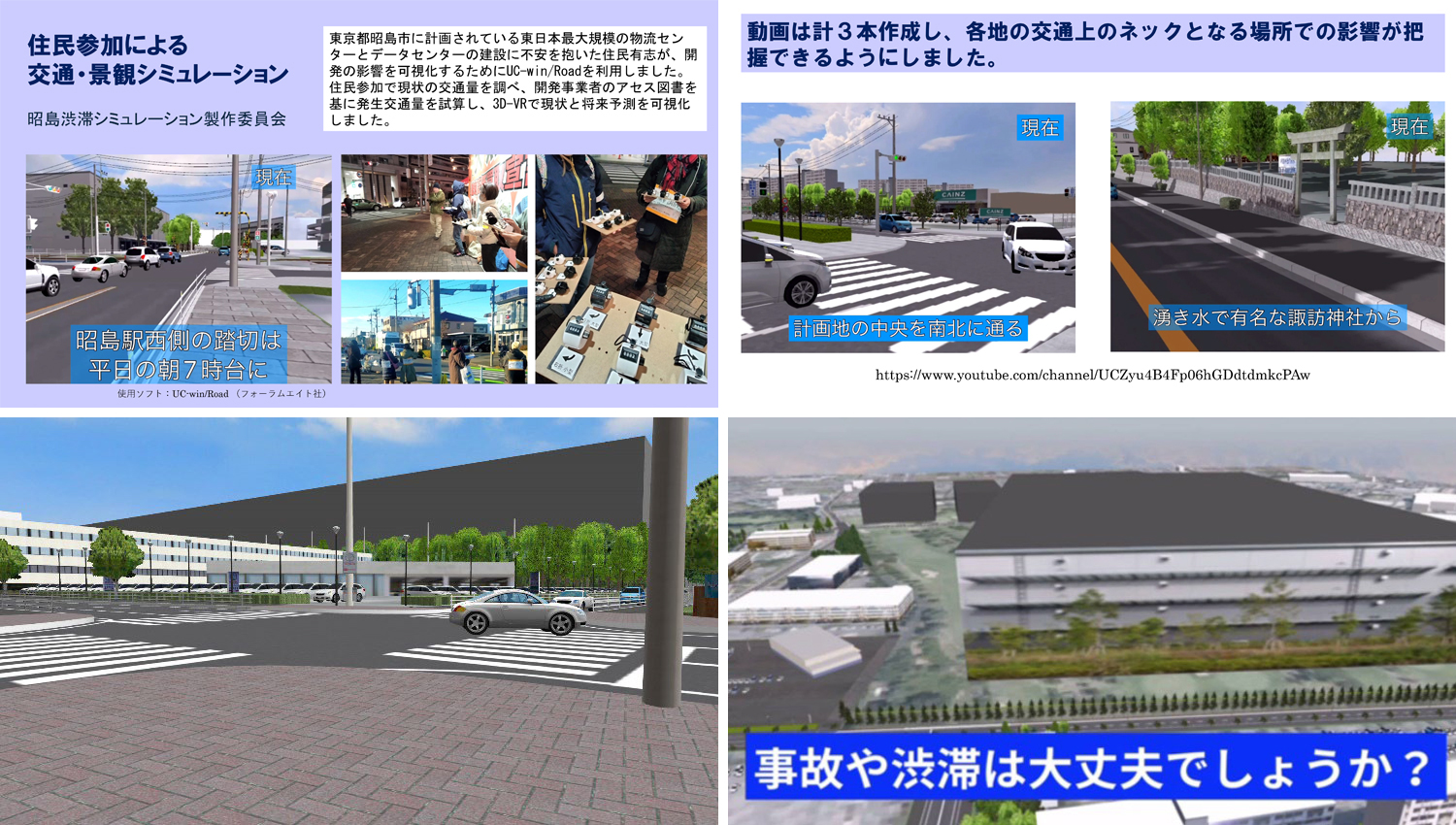 Volunteer residents concerned about the construction of the largest logistics center and data center in East Japan planned to be developed in Akishima City, Tokyo, used UC-win/Road to visualize the impact of the development. The current traffic volume was investigated with the participation of residents, the generated traffic volume was estimated based on the developer's assessment documents, and the current situation and future predictions were visualized in 3D-VR.
 -
 23rd Idea Award
Use of Metaverse and VR for Proposal of Bento Tray Packaging Assembly Line
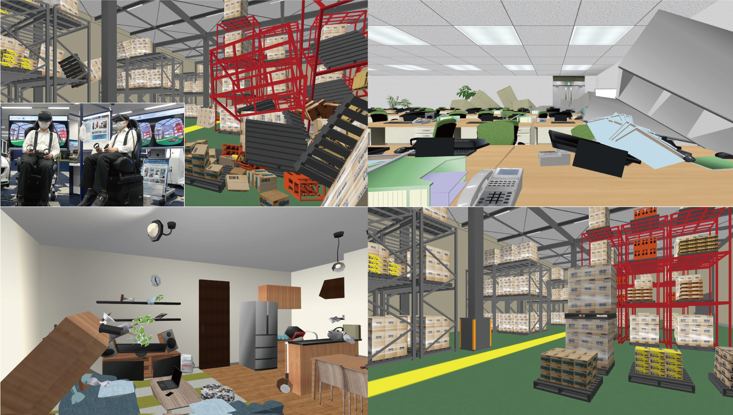
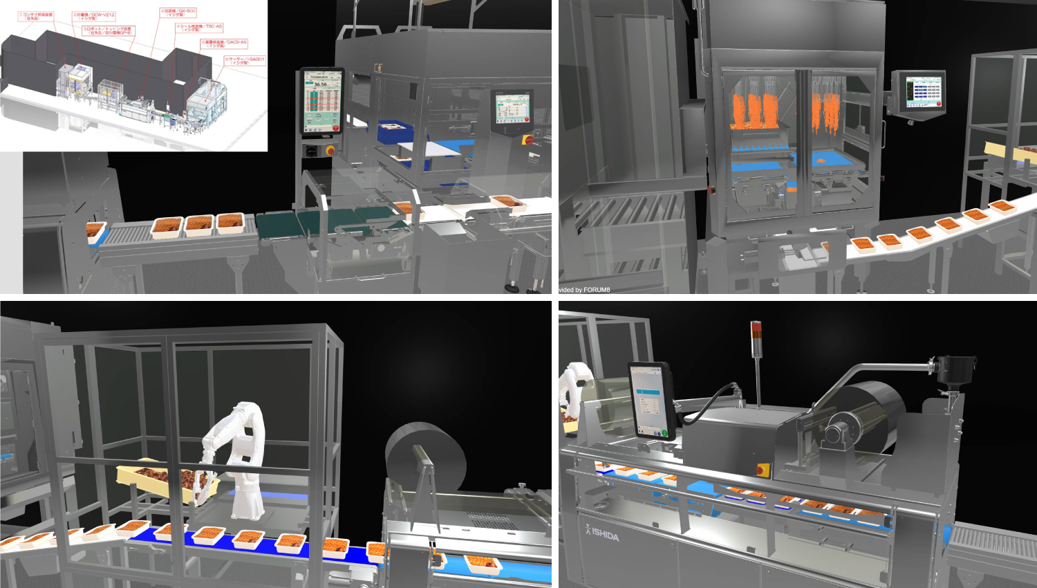 In addition to the proposal of an automated lunch box tray packaging assembly line based on a plan view, we have started a project to realize an assembly line proposal utilizing the Metaverse and VR so that customers can see the assembly line in manner very similar to watching the actual assembly line. It is expected to reveal parts of the assembly line that were not known until the equipment was manufactured and installed. In addition, by using the system with VR devices, it has become possible to study in advance the width of aisles and the feeling of pressure after the machine has been installed. In the future, the company plans to consider various applications, such as using the system for maintenance education.
 -
23rd Essence Award
Tamana City, Kumamoto Prefecture
Visualization of Crowd Flow Data Using 3D Urban Model, and Tamana City Metaverse
 The status of usage of space on an urban scale is visualized by overlaying the 3D urban model from PLATEAU and data about the movement of visitors. Based on this, simulations, etc. will be conducted, aiming for EBPM of space design that will bring liveliness to the region. In addition, Metaverse representing the local landscape and vision of the region will also be constructed to examine options for future urban planning and to promote the attractiveness of the region by utilizing NFT.
 -
23rd Honorable Judge Award Design Award (Prof. Fumio Seki)
Urasoe City, Okinawa prefecture
VR Simulation of Urasoe City Base Site Utilization Plan
 Metaverse and VR simulation of the future image of the former U.S. military base site, which is scheduled to be returned, has been created. The simulation visualizes urban development aimed at creating liveliness, mainly in public spaces, with facades and monuments incorporating traditional Urasoe design, road plans envisioning autonomous vehicles, and development of sloping land along the sea with an emphasis on creating spectacular views. The plan is to be updated as appropriate over the next several years through consensus building with stakeholders.
 -
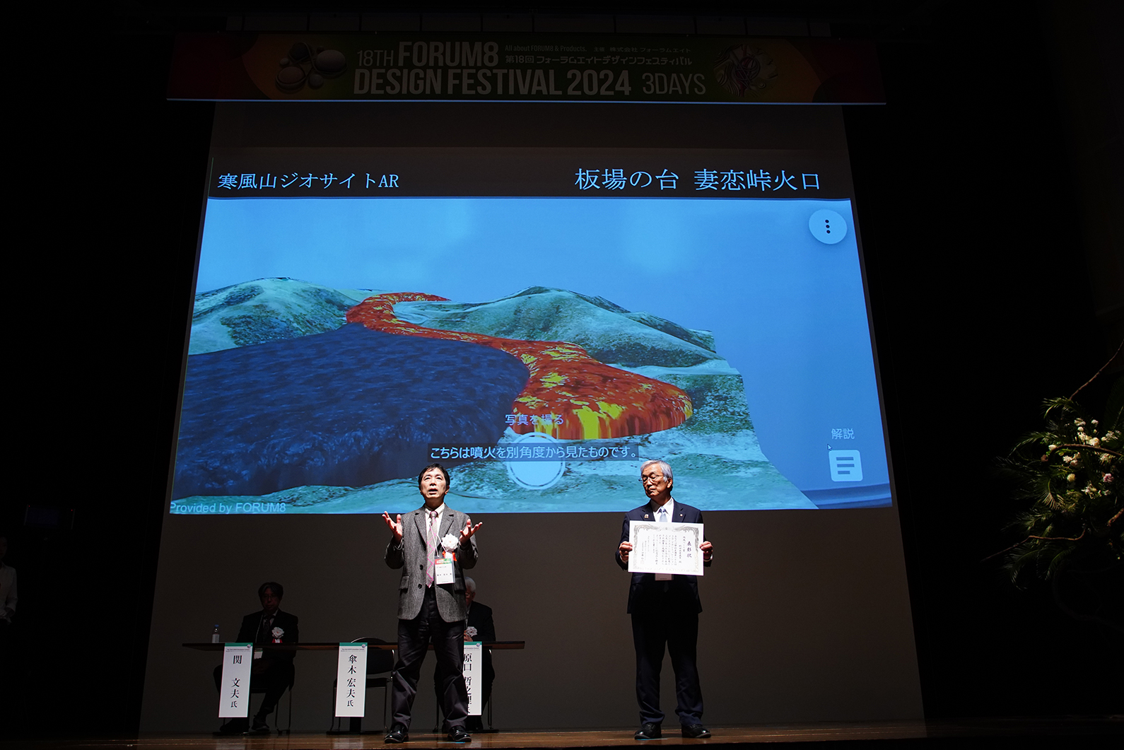
23rd Honorable Judge Award Community Development Award (Mr. Hiroo Kasagi)
Kanpusan Geosite, Akagami Shrine Goshado Metaverse WebAR Project
 Developed to promote tourism and education, this system allows visitors to experience the actual eruptions and topographic changes that occurred in the past at the Kanpusan mountain through Metaverse and WebAR. In addition, at Akagami Shrine Goshado, a nationally designated important cultural property, the legend of 999 stone steps said to have been piled by Oni is reproduced in an intuitive manner via WebAR. In the future, the unique topography of the Wakimoto Castle Ruins is planned to be reproduced using a red 3D map, and contents that reproduce the past is also planned to be constructed.
 -
23rd Honorable Judge Award Traffic simulation Award (Prof. Tetsunori Haraguchi)
KICT(Korea Institute of Civil Engineering and Building Technology)
Verification of V2I Autonomous Cooperative Driving through Linkage with VILS-Micro Simulation
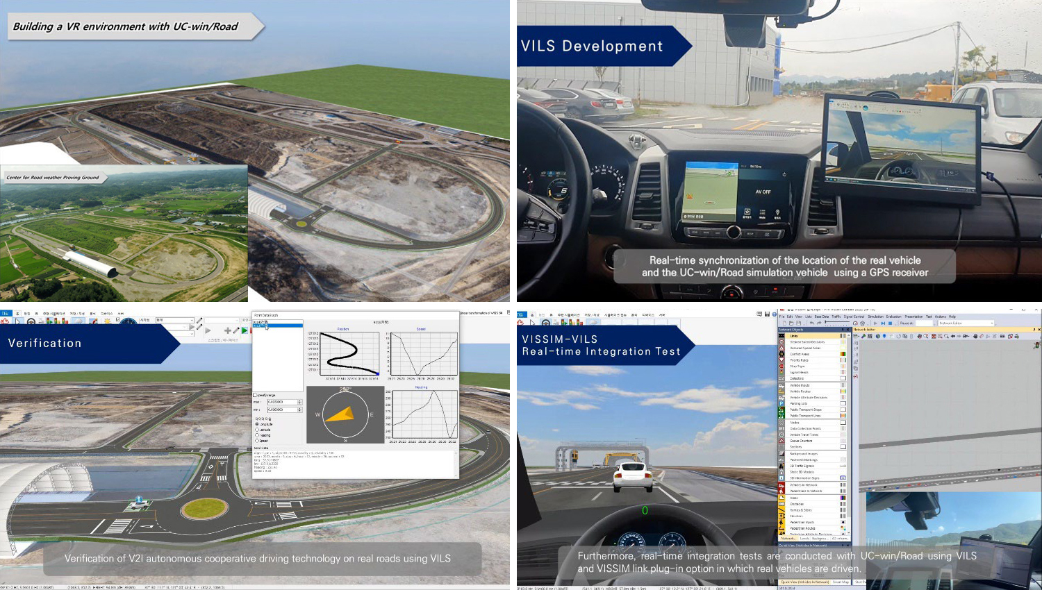 Verifying V2I technology, which provides location information about surrounding traffic to autonomous vehicles from infrastructure when autonomous vehicles have difficulty acquiring sensor data due to bad weather or obstacles. Therefore, we developed VILS (Vehicle in the Loop Simulation), which drives a real car on a real road but generates surrounding traffic in a virtual environment. A GPS receiver was installed in a real car and communicated with a PC installed in the car to synchronize the vehicle location with the VR environment built with UC-win/Road in real time.
-
23rd Nomination Award
Verification of Improving Safety when Taking Over Driving during Autonomous Driving using Smart Bracelets
-
23rd Nomination Award
Construction of Base Data for Safe Driving Evaluation on familiar roads around the Company
-
23rd Nomination Award
MARINE SUPPORT ENGINEERING Co., Ltd.
New Approach to Maintenance and Management using 3D Models
-
23rd Nomination Award
Safety analysis of Gwangju Jisan IC exit ramp based on driving simulation
-
23rd Nomination Award
Review of PM sidewalk driving safety based on PM simulator experiments

-
23rd Nomination Award
KANEHIDE CONSTRUCTION CO., LTD
Nago Main Line Toguchi Bridge Underground Construction Work
-
 The 3rd VR SYSTEM OF THE YEAR
Chugoku Regional Development Bureau, Ministry of Land, Infrastructure, Transport and Tourism
Backhoe MG/MC Experience Simulator
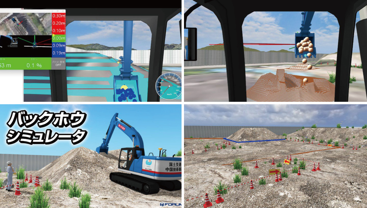 A simulator for experiencing ICT construction (MG, MC) with a backhoe. To promote infrastructure DX, the simulator provides operational guidance and simulated semi-autonomous control of an ICT backhoe as contents for inexperienced operators and beginners. In semi-autonomous control mode, the bucket and arm are calculated to move in accordance with the design surface, simulating construction as designed.
Past Awards PickUp
-
22rd Grand Prix (Highest Award)
Evaluation of user satisfaction according to the gap acceptance behavior of autonomous vehicles
-
-
21st Grand Prix (Highest Award)
3D Real-Time Digital Twin System for Heavy Machinery in Dam Construction Work
-
21st 2nd Prize (Excellence Award)
NIPPON STEEL ENGINEERING CO., LTD.
Simulation to Experience the Effect of Seismic Isolation Devices
-
20th Grand Prix (Highest Award)
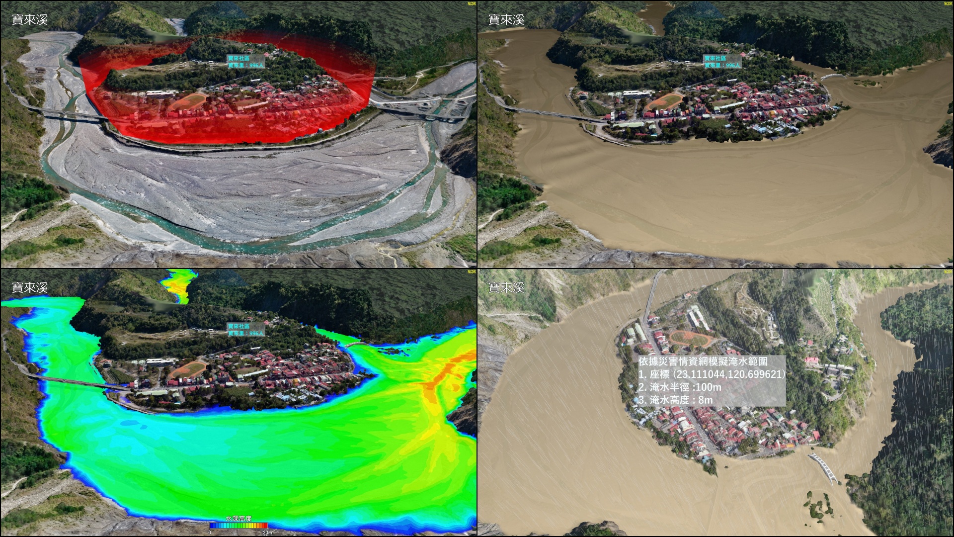
National Science & Technology Center for Disaster Reduction (Taiwan)
Creation of Disaster Scene Using VR And Display of Flood Simulation Analysis Data
-
20th 2nd Prize (Excellence Award)
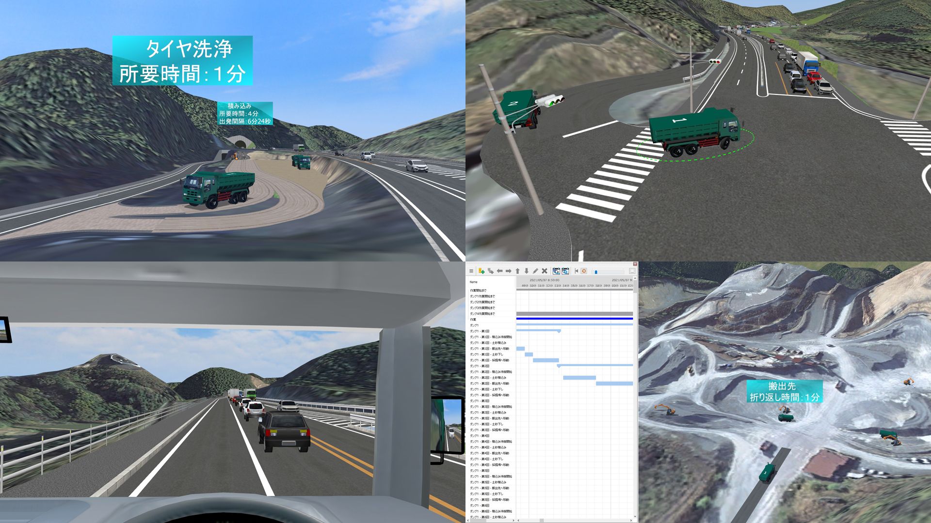
Soil Transport Planning Using Traffic Simulation Analysis
-
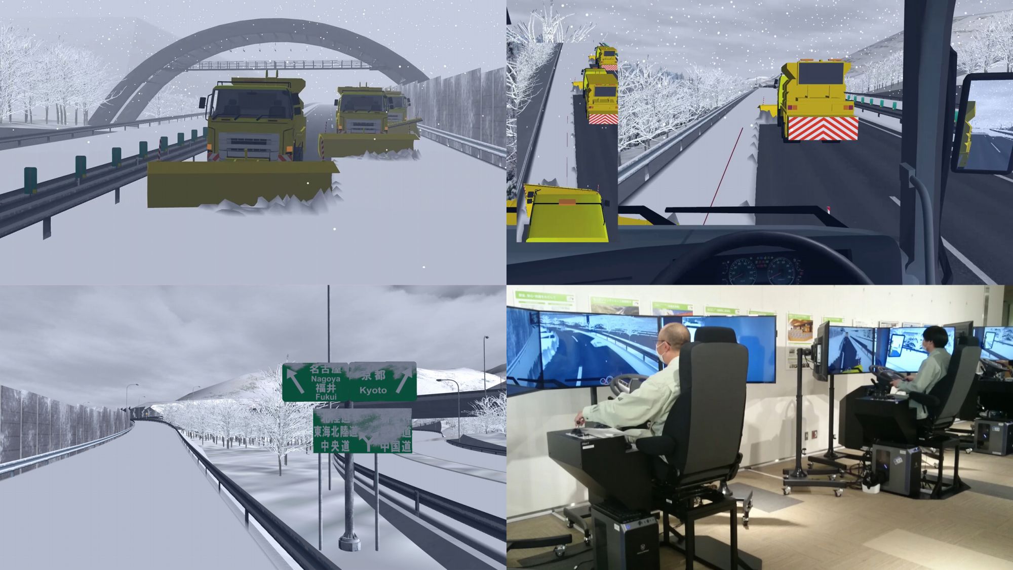
20th 2nd Prize (Excellence Award)
Central Nippon Expressway Company Limited
Simulator for Highway Snow Removal in Echelon Formation
-
19th Grand Prix (Highest Award)
Construction VR simulation during bridge repair
-
19th 2nd Prize (Excellence Award)
Kyushu Technical Office, Kyushu Regional Development Bureau, MLIT
Simulator for remote control training

-
-
-
17th Grand Prix (Grand Prix)
Hokkaido Shinkansen Sapporo Station Planning Simulation
-
-

-
16th Idea Award
Limited Association of Pipeline Data Utilization
Combination of 3D models from Pipeline Survey Data
-
-
15th Honorable Judge Award
Regional Construction AwardAkita Industrial Technology Center / Akita University
Education system of rapid evacuation from tsunami
-
-
-
9th Honorable Judge Award
Design AwardDirectorate general for Kobe city planning
Consensus building and simulation of Kobe City

All Award-Winning Works
-
23rd 3D VR Simulation Contest (2024)
-
- [Grand Prix]
Urban Renaissance Agency
- DX Platform for Umekita 2nd Phase District Urban Planning
- [2nd Prize (Excellence Award)]
Mitsui Consultants Co., Ltd.
- “Proposal for National Resilience using BIM/CIM” - Proposal for Ensuring Safe and Smooth Traffic Flow during Rainfall
Akishima Traffic Congestion Simulation Production Committee
- Traffic and Landscape Simulation with Residents Participating in the Simulation
- [Idea Award]
ISHIDA CO.,LTD.
- Use of Metaverse and VR for Proposal of Bento Tray Packaging Assembly Line
- [Essence Award]
Tamana City, Kumamoto Prefecture
- Visualization of Crowd Flow Data Using 3D Urban Model, and Tamana City Metaverse
- [Honorable Judge Award]
Urasoe City, Okinawa prefecture
- VR Simulation of Urasoe City Base Site Utilization Plan
Oga City, Akita prefecture
- Kanpusan Geosite, Akagami Shrine Goshado Metaverse WebAR Project
KICT(Korea Institute of Civil Engineering and Building Technology)
- Verification of V2I Autonomous Cooperative Driving through Linkage with VILS-Micro Simulation
- [Nomination Award]
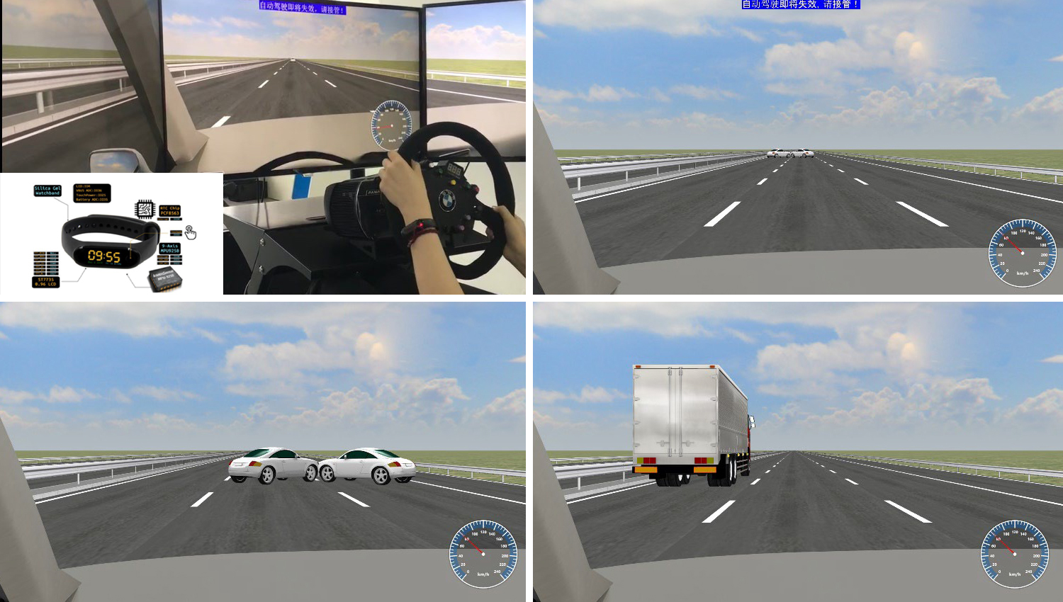
Beihang University
- Verification of Improving Safety when Taking Over Driving during Autonomous Driving using Smart Bracelets
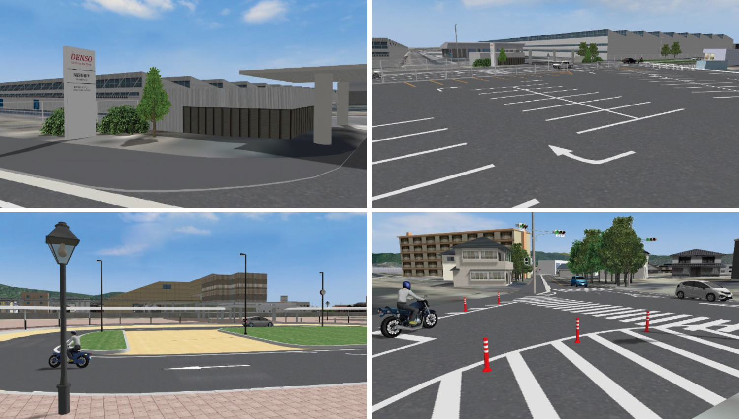
DENSO CORPORATION
- Construction of Base Data for Safe Driving Evaluation on familiar roads around the Company
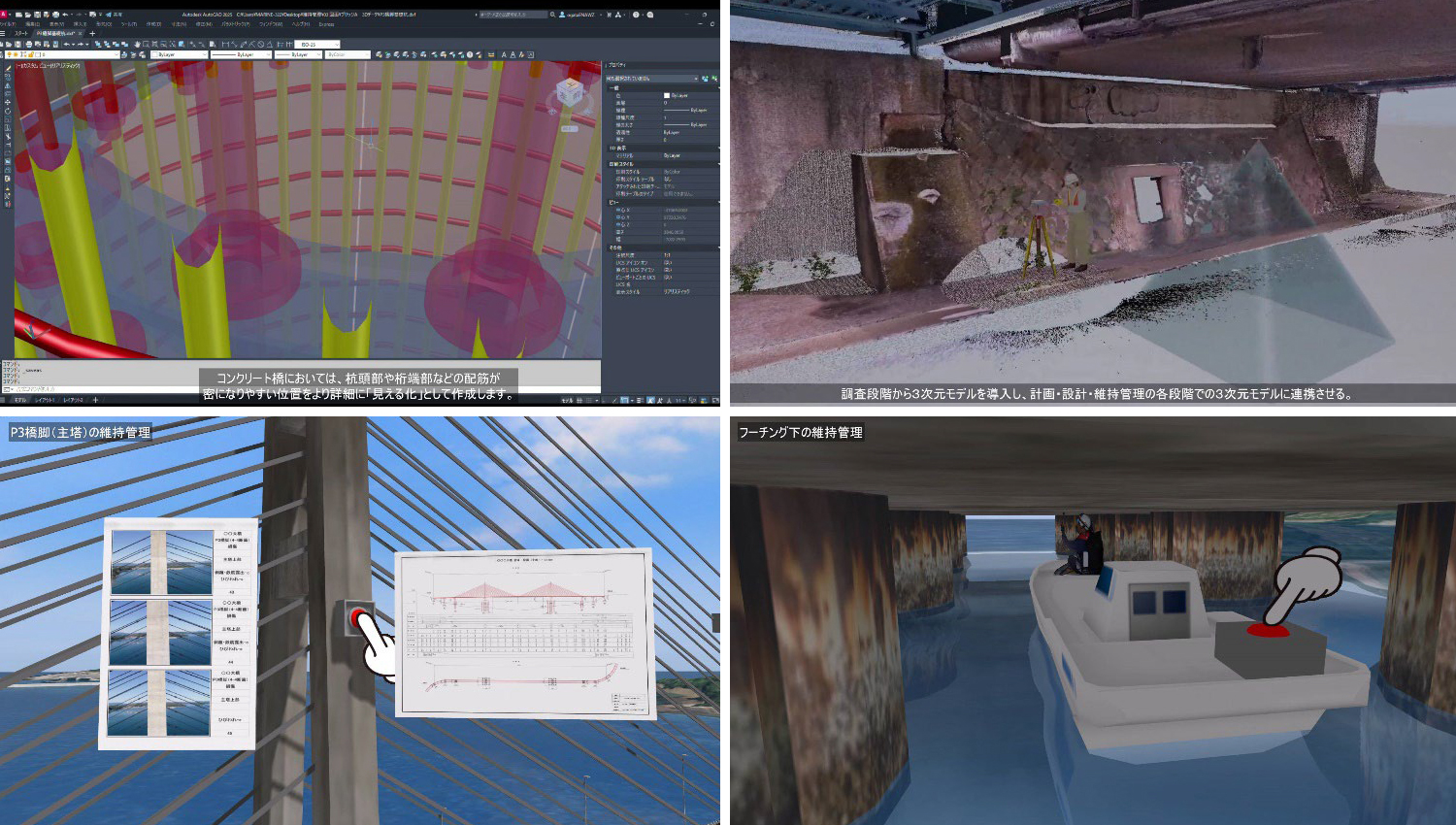
MARINE SUPPORT ENGINEERING Co., Ltd.
- New Approach to Maintenance and Management using 3D Models
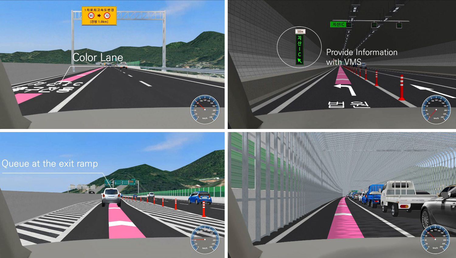
University of Seoul
- Safety analysis of Gwangju Jisan IC exit ramp based on driving simulation
University of Seoul
- Review of PM sidewalk driving safety based on PM simulator experiments
KANEHIDE CONSTRUCTION CO., LTD
- Nago Main Line Toguchi Bridge Underground Construction Work
- [The 3rd VR SYSTEM OF THE YEAR]
Chugoku Regional Development Bureau, Ministry of Land, Infrastructure, Transport and Tourism
- Backhoe MG/MC Experience Simulator
- [Grand Prix]
-
22nd 3D VR Simulation Contest (2023)
-
- [Grand Prix]
University of Seoul
- Evaluation of user satisfaction according to the gap acceptance behavior of autonomous vehicles
- [2nd Prize (Excellence Award)]
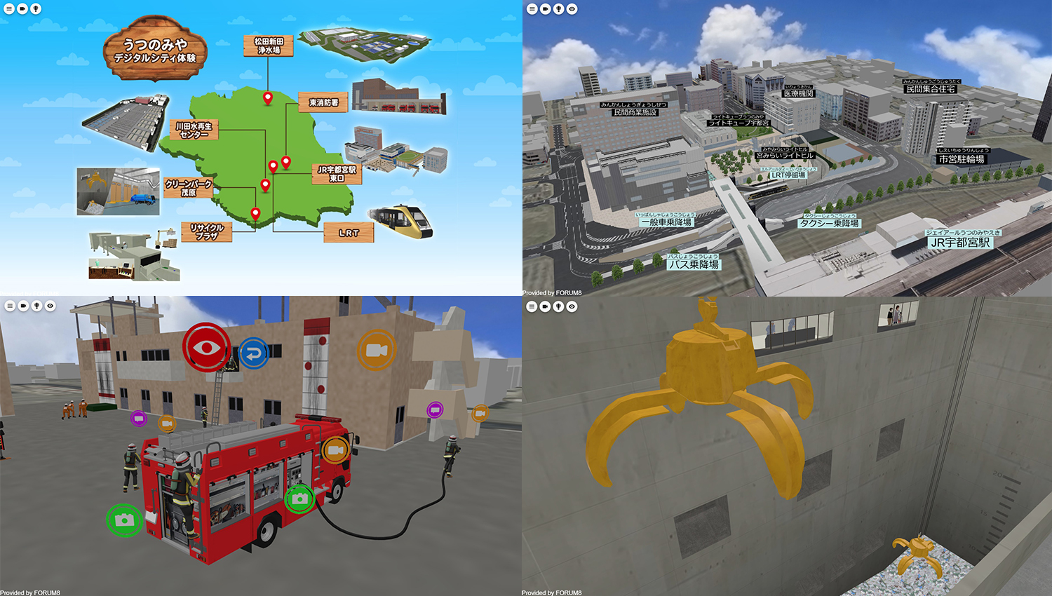
Utsunomiya City
- Utsunomiya Digital City Experience Project
- [Idea Award]
Naha City Tourism Association
- Japan Heritage & Naha Tour WebAR System
- [Essence Award]
Tamana City, Kumamoto Prefecture
- Visualization of disaster risk using 3D city model of Tamana City
- [Honorable Judge Award]
Oriental Consultants Co., LTD.
- VR simulation of human flow using AI camera
Keiyo Sokuryo
- Explore the old town of the Sawara district in VR
Takenaka Civil Engineering & Construction Co., Ltd.
- Machine guidance information display system using XR
- [Nomination Award]
Mitsui Consultants Co., Ltd.
- "Smooth information sharing of landslide-prone areas using the metaverse" ~iHazard map project~
T-NET JAPAN Co., Ltd.
- Training simulation to verify footing and cast-in-place pile installation conditions
Kanahide Construction Co., Ltd.
- Kochi Interchange Line bridge maintenance work (D ramp superstructure)
SmartDrive Sdn. Bhd. & Perusahaan Otomobil Kedua Sdn Bhd
- Hazard-Sensing VR Simulation System
Daewoo Engineering & Construction Co., Ltd.
- Evaluation of driving safety and comfort of urban highway deep underground tunnels
TOM’S INC. / WONDER VISION TECHNO LABORATORY
- Maebashi city safe driving ability diagnosis simulator
- 【The 2nd VR SYSTEM OF THE YEAR】
Tohoku Engineering Office, the Ministry of Land, Infrastructure, Transport and Tourism
- Digital DX training materials and snow removal simulator
- [Grand Prix]
-
21st 3D VR Simulation Contest (2022)
-
- [Grand Prix]
TAISEI CORPORATION
- 3D Real-Time Digital Twin System for Heavy Machinery in Dam Construction Work
- [2nd Prize (Excellence Award)]
NIPPON STEEL ENGINEERING CO., LTD.
- Simulation to Experience the Effect of Seismic Isolation Devices
- [Idea Award]
Jeollabuk-do Traffic Culture Training Institute
- Driving Ability Evaluation System for Elderly Drivers
- [Essence Award]
Oriental Consultants Co., LTD.
- VR Simulation Reproducing Traffic around Hon Atsugi Station
- [Honorable Judge Award]
NIPPON STEEL TEXENG.CO.,LTD.
- Simulation of Traffic in a Factory Premise when Workers are Commuting to and from Work
NiX Co., Ltd.
- Research of Life Extension Measures For Maintenance Management of Bridges in Mountainous Area
Aichi Prefectural University
- Vehicle-Bicycle-Pedestrian Coordination Simulator System
- [Nomination Award]
Shenzhen University
- Urban Underground Roads' Traffic Signs and VR Simulation for Safety Assessment
Sangyo Kaihatsu Consultant CO., LTD.
- VR Simulation for Bridge Landscape Design
Mitsui Consultants Co., Ltd.
- Promotion of Wind Power Generation Business Using DX Technology (3DVR and PLATEAU)
Kanahide Construction Co.,Ltd.
- Simulation of Bridge Superstructure Construction
- [VR SYSTEM OF THE YEAR]
Ministry of Land, Infrastructure, Transport and Tourism (MLIT)
- Construction DX Challenge (Remote Construction Demonstration) Digital Twin System
- [Grand Prix]
-
20th 3D VR Simulation Contest (2021)
-
- [Grand Prix]
National Science & Technology Center for Disaster Reduction (Taiwan)
- "Creation of Disaster Scene Using VR And Display of Flood Simulation Analysis Data"
- [2nd Prize (Excellence Award)]
MAEDA CORPORATION
- "Soil Transport Planning Using Traffic Simulation Analysis"
Central Nippon Expressway Company Limited
- "Simulator for Highway Snow Removal in Echelon Formation"
- [Idea Award]
Department of Transportation, Taipei City Government
- "Bus Driving Simulation System for Traffic Safety Promotion"
- [Essence Award]
Akamatsu Co., Ltd.
- "First in Shikoku! 'Akamatsu Hybrid Expo' toward New Normal Era"
- [Honorable Judge Award]
Hanshin Expressway Company Limited
- "VR to Announce Safety Measures on Hanshin Expressway Route 1 Loop Line"
Nikaho city / NIHON TECHNOS CO., LTD.
- "VR Simulation Reproducing Kitamaebune in Nikaho City"
National Institute for Land and Infrastructure Management (NILIM), Ministry of Land, Infrastructure, Transport and Tourism (MLIT)
- "Cutting Edge of Infrastructure DX Research - Virtual NILIM and 4K VR Simulator -"
- [Nomination Award]
NiX Co., Ltd.
- "VR Simulation for Visibility of New Traffic Signals"
Research Institute of Highway Ministry of Transport (China)
- "VR Simulation of Traffic Safety on Expressways in High Mountain Areas"
University of Seoul
- "Research for Preferred type of Autonomous Driving"
T-NET JAPAN Co., Ltd.
- "Survey VR Training Simulation"
Solar Kanamori
- "Plan of Small Hydroelectric Power Plant at Chigawa River"
- [Grand Prix]
-
19th 3D VR Simulation Contest (2020)
-
- [Grand Prix (Highest Award)]
SHO-BOND Holdings Co., Ltd.
- "Construction VR simulation during bridge repair"
- [2nd Prize (Excellence Award)]
Kyushu Technical Office, Kyushu Regional Development Bureau, Ministry of Land, Infrastructure, Transport and Tourism
- "Simulator for remote control training"
- [Idea Award]
Denso Corporation
- "VR data for driving reaction test"
- [Essence Award]
Seoul Metropolitan Government Infrastructure Headquarters
- "Road design for "Changing western highways to urban roads" by VR"
- [Honorable Judge Award]
Sakaiminato City
- "A complex facility like a plaza where everyone gathers Sakakiminato Civic Center (provisional name)"
Mitsui Consultants Co., Ltd.
- "Examination of effective construction plans in road improvement projects"
IWATA CHIZAKI Inc.
- "Traffic restriction simulation due to intersection construction in Sapporo"
- [Nomination Award]
Chuo Sekkei Inc.
- "Smart IC and VR driving simulation"
Research Institute of Highway Ministry of Transport
- "Environment simulation assessment on tunnel lighting"
TOHNICHI Co., Ltd.
- "Consideration on scenery of viaduct on Route 414"
- [Grand Prix (Highest Award)]
-
18th 3D VR Simulation Contest (2019)
-
- [Grand Prix (Highest Award)]
TUMS Urayasu Hospital
- "Safety driving diagnosis simulator"
- [2nd Prize (Excellence Award)]
East Nippon Expressway Company Limited
- "VR experience type training system"
- [Idea Award]
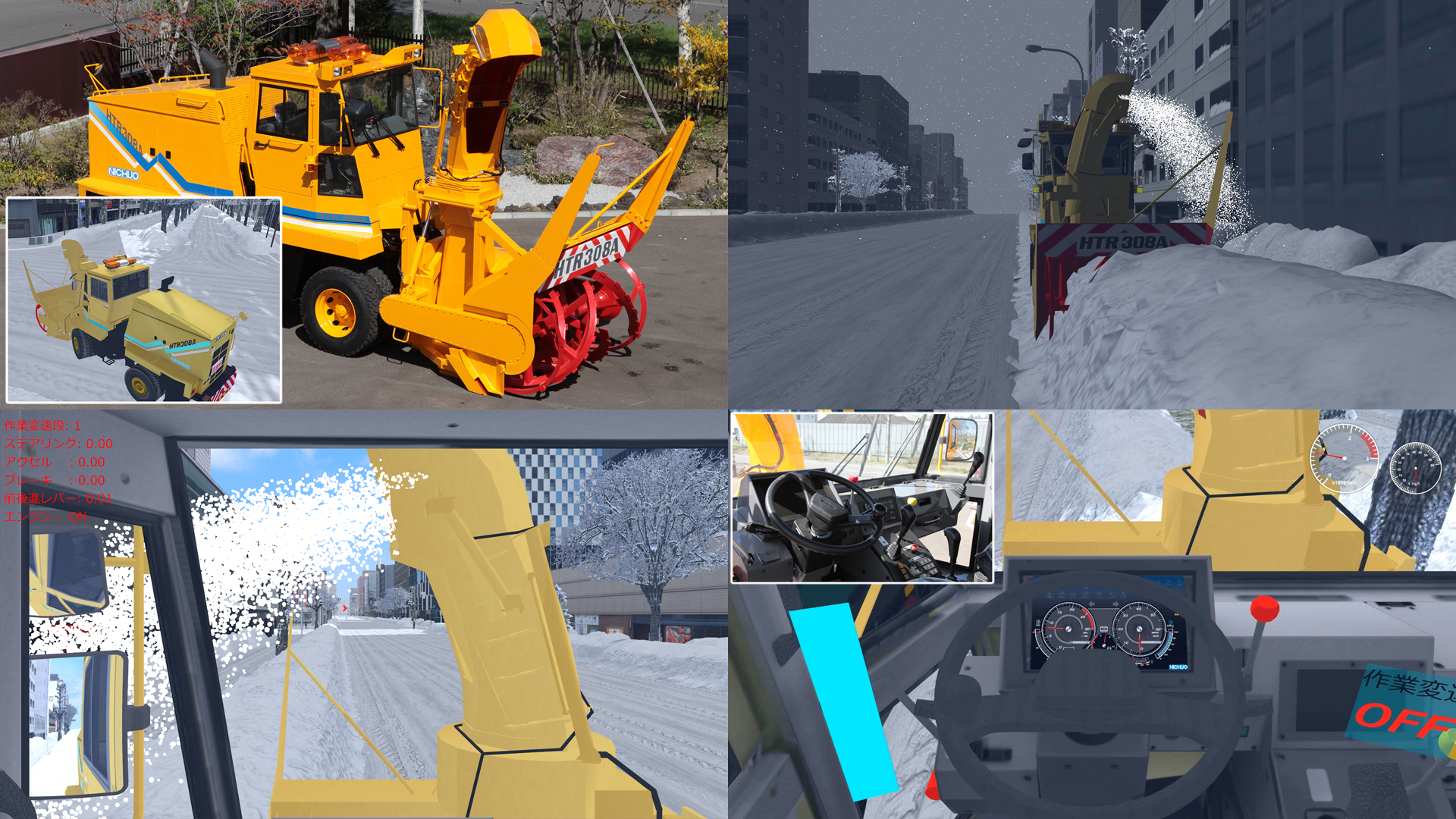
NICHIJO CORPORATION
- "Snow blower simulator"
- [Essence Award]
Kyoto Kogakuin High School
- "DS simulation of speed hump markings at Honmachi dori street"
- [Honorable Judge Award]
Hanshin Expressway Company Limited
- "Vehicle trajectory simulation on Hanshin Expressway"
National Science and Technology Center for Disaster Reduction (Taiwan)
- "Scenario construction and VR display of 3D environmental design VR software"
KEIKAN SEKKEI TOKYO Co., Ltd.
- "Bridge light-up simulation along Meguro River"
- [Nomination Award]
FUKUCHIGUMI Inc.
- "VR of BOX construction at Ajyagawa"
Toho Development Co., Ltd.
- "VR simulation of social infrastructure planning"
Iwakura Hospital
- "Driving determination and reaction diagnosis simulator"
Denso Corporation
- "Simulator reproducing the feeling of driving in Shinagawa city"
National University of Kaohsiung (Taiwan)
- "VR for urban planning in Cijin Island"
- [Grand Prix (Highest Award)]
-
17th 3D VR Simulation Contest (2018)
-
- [Grand Prix (Highest Award)]
Hokkaido Railway Company
- "VR simulation for Hokkaido Shinkansen Sapporo station design and construction"
- [2nd Prize (Excellence Award)]
Tho.La.Consulting
- "3DVR of Winding tower in Shime mining factory and Related facilities (in 1964)"
AKISHIMA LABORATORIES (MITSUI ZOSEN) INC.
- "VR data for ship operation simulator"
- [Idea Award]
Central Police University Republic of China (Taiwan)
- "Safety driving simulator for university students"
- [Essence Award]
Hitachi Construction Machinery Co., Ltd.
- "Autonomous driving simulation of mining dump truck"
Kanagawa Construction Bureau, Metropolitan Expressway Company Limited
- "VR simulation of evacuation from Metropolitan Expressway Yokohama Kita line"
- [Honorable Judge Award]
Tendaishu Kyououzan Monjuin Enyuuji
- "Test VR data for projection mapping on Enyuuji Temple"
Denso Corporation
- "Dual drive EPS system simulator"
Kyoto Kogakuin High School
- "VR data utilized for Nanase River renovation plan"
- [Nomination Award]
Mitsui Consultants Co., Ltd.
- "High resolution satellite photos applied to VR building and terrain models"
Hyundai Motor Group
- "Testing of ADAS function of Vehicle-in-the-Loop system using UC-win/Road"
Wuhan University of Technology
- "Evaluation of road markings for speed reduction on Wuhan Yangtze Great Bridge"
DOROKOGYO Co., Ltd.
- "VR construction management - utilization of 3D in paving work -"
- [Grand Prix (Highest Award)]
-
16th 3D VR Simulation Contest (2017)
-
- [Grand Prix (Highest Award)]
Meiwa Sky Support Co., Ltd.
- "Education training of Haneda Airport by VR simulator"
- [2nd Prize (Excellence Award)]
Keisuke Ijiri office
- "Reproduction of the tramway line and its surroundings in Omuta city"
Korea Transportation Safety Authority
- "Mobile type safety education experience 4D VR simulation"
- [Idea Award]
Kanro Jyoho Katsuyo Yugen Sekinin Jigyo Kumiai (Limited Association of Pipeline Data Utilization)
- "Integration of 3D models from sewerage pipe line investigation data"
- [Essence Award]
University of Seoul
- "VR for research on the effects of digital signage on driving operation and driver performance"
- [Honorable Judge Award]
Kisarazu City
- "A redevelopment proposal based on a model of the maritime area in Kisarazu city"
Fushimi Technical High School in Kyoto (Kyoto Kogakuin High School)
- "A proposal for the emergency planning using VR of a huge earthquake"
PIONEER CORPORATION
- "HMI VR cockpit simulation during autonomous driving"
- [Nomination Award]
Sagae Survey Civil Engineering Co., Ltd.
- "A proposal for the initial improvement of the government-designated historic site of the ruin of Aterazawa Tateyama castle in Oe, Yamagata using 3D point cloud data"
Mitsui Consultants Co., Ltd.
- "i-hazard map PROJECT -Proposal of the next generation i-hazard map concept-"
- [Grand Prix (Highest Award)]
-
15th 3D VR Simulation Contest (2016)
-
- [Grand Prix (Highest Award)]
Sakaiminato City
- "Mizuki Shigeru Road in Sakaiminato City"
- [2nd Prize (Excellence Award)]
Fushimi Technical High School in Kyoto
- "Fushimi Technical High School, alma mater that is passed down the generations"
- [Idea Award]
Korea National Disaster Management Institute (NDMI)
- "Evacuation training and experiment in the chemical industry precinct by using walking VR simulator"
- [Essence Award]
Mitsui Consultants Co., Ltd.
- "Facility planning of a ski field considering user's viewpoint"
- [Honorable Judge Award]
Denso Corporation
- "Experience simulation of ADAS features"
Akita Industrial Technology Center / Akita University
- "Education system of rapid evacuation from tsunami"
Arcbazar
- "Works expression in Obama Center Competition"
- [Nomination Award]
Tongji University
- "Departing and gathering traffic simulation of large traffic core"
Sumitomo Mitsui Construction Co., Ltd.
- "Simulation of bridge girder construction via overhang construction technique"
Iwasaki CO., LTD.
- "Society infrastructure VR - production improvement by CIM"
- [Grand Prix (Highest Award)]
-
14th 3D VR Simulation Contest (2015)
-
- [Grand Prix (Highest Award)]
Kitsuki City, Oita Prefecture
- "Kitsuki City jokamachi (castle town) future proposals"
- [2nd Prize (Excellence Award)]
Tho.La.Consulting
- "VR for Rebuilding Ruins"
- [Idea Award]
Mitsui Consultants, Kansai Branch
- "Using VR to Communicate to the Locals Over Debris Avalanche Countermeasure"
- [Essence Award]
Fushimi Technical High School in Kyoto
- "Repair simulation in Higashi Takase river 2015"
- [Honorable Judge Award]
Awaji City Hall, Hyogo Prefecture
- "Dream Zone - Creating the Town You Want to Return! - Awaji City Yumebutai Sustainable Park, Compact City Project"
Mitsumi Electric Co., Ltd.
- "Smart Technology Concept Simulation"
RIOH
- "Underground rapid road design project"
- [Nomination Award]
SOZOTECH
- "The landscape VR simulation of The Town with Fishing Port"
Transport for NSW, Centre for Road Safety In collaboration with University of Wollongong / SMART Infrastructure Facility (scenarios)
- "CITI (Cooperative Intelligent Transport Initiative) project"
Nagoya University
- "Nagoya City Street VR Simulation -Shaping a Green Mobility Society - "
Qingdao Municipal Engineering Design Institute, China
- "Design of the cloverleaf interchange"
- [Grand Prix (Highest Award)]
-
13th 3D VR Simulation Contest (2014)
-
- [Grand Prix (Highest Award)]
TOYOTA MOTOR CORPORATION
- "Cooperative ITS Driving Simulator"
- [2nd Prize (Excellence Award)]
Fushimi Technical High School in Kyoto
- "Simulation for environmental upgrading around Higashi Takase river"
- [Idea Award]
Nisso Industries Co., Ltd.
- "QuikDeck Promotion VR Data"
- [Essence Award]
UTMS Society of Japan
- "DSSS Experience VR Data"
- [Honorable Judge Award]
atelier DoN
- "Residential Building Design VR Simulation for N House"
SOZOTECH
- "Construction VR Simulation for the bridge replacement"
Sanyu Eng. Ltd
- "Onuma Floating Istands landscape simulation"
- [Nomination Award]
Doshisha University
- "Driving support agent VR simulation"
ITS Bordeaux La CUB & BMIA
- "G'EduCom in Bordeaux"
Michael Baker International
- "Redlands California Flood Analysis Project using VR"
Tokyo Metro Co., Ltd.
- "Tokyo Metro Simulator"
- [Grand Prix (Highest Award)]
-
12th 3D VR Simulation Contest (2013)
-
- [Grand Prix (Highest Award)]
Iwasaki CO., LTD.
- "VR Simulation for Traffic Regulation to Divert Traffic During Night Construction"
- [2nd Prize (Excellence Award)]
Qube Ports and Bulk
- "Driver Training and Assessment System of PCC (Pure Car Carrier) Simulator"
Pacific Consultants Co., LTD.
- "VR Simulation that uses Tsunami/Evacuation Analysis Results"
- [Idea Award]
TS TECH Co., Ltd.
- "VR Simulator for Experiencing an Intelligent Driver's Seat"
- [Essence Award]
Graduate School of Osaka University
- "VR Model of Osaka's Underground Shopping Mall"
- [Honorable Judge Award]
University of Seoul
- "The Use of VR Simulation to Evaluate Safety of a New Type of Road (2+1) as well as Drivers' Behavior"
SOZOTECH
- "VR Simulation for an Urban Expressway with U-Turn Road"
Noda Engineering Co., Ltd.
- "Proposal of a New Engineering Method for Installing Single Track Railway Bridges"
- [Nomination Award]
Korea Transportation Safety Authority(TS)
- "Proposed Improvements on Special Traffic Safety Status Investigation in Republic of Korea"
ORIENTAL CONSULTANTS Co., Ltd.
- "VR was used to promote safety and use of the Narita Smart Interchange, which consequently streamlined business!"
Virtual Simulation and Training Inc.(VSAT)
- "3D VR Training Environment for Automobile Driver"
HAGIWARA ELECTRIC CO., LTD.
- " VR Simulator for Dangerous Scene Assessment Used in the Discipline of In-Vehicle ADAS "
- [Grand Prix (Highest Award)]
-
11th 3D VR Simulation Contest (2012)
-
- [Grand Prix (Highest Award)]
TOYOTA Motor Corporation
- "Project for sharing system of compact EV vehicle using VR simulation"
- [2nd Prize (Excellence Award)]
Kyushu-orient Servey&Design Co., Ltd.
- "Simulation for a landscaping plan using point cloud data"
BMIA (France)
- "Training system for tunnel administrator via VR"
- [Idea Award]
Keisuke Ijiri
- "Restoring the Oomuta street car in 1952 and the town along its railroad"
- [Essence Award]
Iiyama city Construction channel department City planning section/Section for maintening the surrounding of the station of Shinkansen bullet train
- "Simulation for urban planning in front of Hokuriku Shinkansen "Iiyama station""
- [Honorable Judge Award]
Nishitetsu C.E. Consultant Co., Ltd
- "Aiming for "Alleviating traffic jams in the original route especially near railroad crossings and narrow bridges""
JEITA (Japan Electronics and Information Technology Industries Association) Car Electronics Commitee / Car Electronics Promoting Comitee
- "Experience simulator for ITS spot service"
Material Hakuba Co., Ltd.
- "Simplified assessment for landslide extraction in the south of Nakatusna"
- [Nomination Award]
Korea Transportation Safety Authority
- "Improving the intersection which has a lot of accident and analysing the effect using DSLog"
Kusakabe Electric & Machinery Co., Ltd.
- "Simulation for pipe plant facility"
Fukui National College of Technology
- "Simulation for landslide disaster in Suzawa district of Shinshiro city, Aichi prefecture"
- [Grand Prix (Highest Award)]
-
10th 3D VR Simulation Contest (2011)
-
- [Grand Prix (Highest Award)]
Japan Railway Construction, Transport and Technology Agency
- "System for checking the position where equipments are installed"
- [2nd Prize (Excellence Award)]
Vehicle Information and Communication System Center
- "VICS Driving simulator"
- [Idea Award]
TOEI Company, Ltd
- "Kamen Rider, cyclone racing simulator"
- [Essence Award]
Amlux TOYOTA Co., Ltd
- "ITS driving simulator"
- [Development Award]
Graduate school of University of Tokushima
- "Bicycle simulator"
- [Honorable Judge Award]
Tatsumi Architects & Engineers
- "Simulation for improving the route taken by students going to and from school"
Roads and Traffic Authority of NSW (RTA)
- "3D VR modeling of the Hunter Expressway"
Asahi Sokuryo Sekkei Co., Ltd
- "VR simulation for consensus creation in the traffic nodes improvement project"
- [Nomination Award]
City of Nedlands (Australia)
- "3D VR modeling of Black Spot Project"
Graduate School of University of Tokyo
- "Comparative approach to visibility of signboards using VR simulation"
- [Grand Prix (Highest Award)]
-
9th 3D VR Simulation Contest (2010)
-
- [Grand Prix (Highest Award)]
Faculty of Policy Studies, Kansai University
- "Proposal of underground installation of Hanshin expressway and improved city using VR"
- [2nd Prize (Excellence Award)]
East Nippon Expressway Co., Ltd
- "Highway driving simulator system"
- [Idea Award]
Faculty of Engineering, Gunma University
- "Debris avalanche simulation"
- [Essence Award]
Abley Transportation Consultants Limited(New Zealand)
- "STRIDING AHEAD! Modeling Unpredictable Pedestrian Road Crossing Behavior"
- [Development Award]
SK Energy Co., Ltd. (Korea)
- "A publicity drive simulator for EV and charging system in SmartGrid"
- [Honorable Judge Award]
Asunaro Aoki Construction Co., Ltd
- "VR simulation for the proposal of the ground facilities construction"
Korea Transportation Safety Authority(Korea)
- "VR simulation of the crosswalk construction planning for the prevention of traffic accidents"
Directorate general for Kobe city planning
- "VR utilization for consensus-building toward landscape formation of design city, Kobe"
- [Nomination Award]
Seoul National University (Korea)
- "VR simulation in disasters using P-SIM(Pedestrian flow simulation)"
Taisei Engineering Co., Ltd
- "VR data utilization and DS driving analysis system"
FUJICON PRIANGAN PERDANA, PT(Indonesia)
- "BANJAR Water Park"
- [Grand Prix (Highest Award)]
-
8th 3D VR Simulation Contest (2009)
-
- [Grand Prix (Highest Award)]
Metropolitan Expressway Company Limited
- "VR Data for Ohashi Junction of Metropolitan Expressway"
- [2nd Prize (Excellence Award)]
Korea Road Agency (Korea)
- "VR simulation of Design Change of Korea Namhae Highway"
- [Idea Award]
Noda Engineering Co., Ltd.
- "Simulation of Railway Bridge Beam Construction Work"
- [Essence Award]
Graduate School of Informatics Kyoto University
- "Simulation of Traffic in Kyoto City"
- [Overseas Award]
Ourston Roundabout Engineering, Inc.(USA)
- "VR Data of Roundabouts in US 41 Project"
- [Honorable Judge Award]
Hosei University
- "Proposal of Reproducing Environmentally-friendly Waterland City Hino"
Beijing Water Cube Digital Technology Co.,Ltd. (China)
- "VR Project of Beijing Guomian Group (Jingmian Second Factory)"
Nishitetsu C.E.Consultant Co.,Ltd
- "Creation of Road Which Is Suitable for Aso Kuju National Park"
- [Nomination Award]
Temasek Polytechnic (Singapore)
- "Road Monitoring System"
GTSM Inc. (Korea)
- "Transfer VR simulation at Junjon Service Area in Korea"
Shanghai Chikushi Construction Design Co., Ltd. (China)
- "VR Simulation of Pedestrian Behavior at Pedestrian Bridge Construction"
- [Grand Prix (Highest Award)]
-
7th 3D VR Simulation Contest (2008)
-
- [Grand Prix (Highest Award)]
National Agency for Automotive Safety & Victims' Aid
- "Simulated driving diagnosis system using CG simulation"
- [2nd Prize (Excellence Award)]
Osaka University, Graduate School of Engineering, Division of Sustainable Energy and Environmental Engineering
- "Sakai City Oshoji LRT Project VR data"
- [Idea Award]
Noda Engineering Co., Ltd.
- "Erection of construction girders for underground passageway construction in train stations"
- [Essence Award]
Daido Institute of Technology, Department of Civil Engineering and Environmental Design
- "VR utilization case in educational curriculum"
- [Overseas Award]
CION Media Company (Turkey)
- "AFRICA_SUDAN Project"
- [Honorable Judge Award]
Busan Regional Construction & Management Office (Korea)
- "Sancheong-Sudong VR Simulation"
Taisei Engineering Co., Ltd.
- "Simulation of an evacuation in an aging society using 3D VR"
Arizona State University(USA)
- "Digital Phoenix Project by UC-win/Road III"
- [Nomination Award]
Asahi Kasei Construction Materials Corporation
- "EAZET construction VR Simulation"
Haihe River Water Conservation Commission, Ministry of Water Resources (China)
- "3D Exhibition of North Grand Canal Ecological Rehabilitation"
Shanghai T.E.F Building Safety Consulting Co.,Ltd (China)
- "Evacuation Simulation of Hongqiao Traffic Network Center Building"
Tsinghua Sware Software Hi-Tech Co. Ltd. (China)
- "Shenzhen Yantian Port modern distribution center"
- [Grand Prix (Highest Award)]
-
6th 3D VR Simulation Contest (2007)
-
- [Grand Prix (Highest Award)]
Kanagawa Construction Bureau, Metropolitan Expressway Company Limited
- "Ishikawa-cho Junction Simulation"
- [2nd Prize (Excellence Award)]
National Institute for Land and Infrastructure Management, Ministry of Land, Infrastructure and Transport / Highway Industry Development Organization
- "SMARTWAY 2007 VR Simulation"
- [Idea Award]
Meijo University, Faculty of Science and Technology, Department of Information Engineering
- "Driving Ability Measurement for Senior Citizen VR Simulation"
- [Essence Award]
Meishi Road Buresau, Chubu Regional Bureau, Ministry of Land, Infrastructure and Transport
- "Asuke By-pass Road Simulation"
- [Overseas Award]
Nepoch Consultant Co., Ltd.
- "Qingdao JiaoZhou bay Tunnel Project"
- [Honorable Judge Award]
Huyo architect office Co., Ltd.
- "Katsunuma Station Square Park Simulation"
Arizona State University
- "Digital Phoenix Project by UC-win/Road II"
Civil and Environmental Engineering , Faculty of Engineering and Design, Hosei University
- "Hosei University around Ichigaya Campus VR Simulation"
- [Grand Prix (Highest Award)]
-
5th 3D VR Simulation Contest (2006)
-
- [Grand Prix (Highest Award)]
Kanagawa Construction Bureau, Metropolitan Expressway Company Limited
- "Simulation carried out at the Daishi junctionand ventilation place"
- [2nd Prize (Excellence Award)]
Bureau of Construction Tokyo Metropolitan Government Minami Tama Higashibu Construction Office/ Japan Bridge & Structure Institute, Inc.
- "Machida city, Aibara-Tsuruma line simulation"
- [Idea Award]
China Shanghai Institute of Waterways
- "The Simulation of Ecological Restoration of Yunnan Province Erhai Lakeside Area"
- [Essence Award]
Nihon University College of Science and Technology Department of Transportation Engineering and Socio-Technology
- "The VR simulation for the landscape comparison of International avenue transit mall"
- [Overseas Award]
China Nepoch Consultant Co. Ltd
- "2010, Shanghai international exhibition central axis simulation"
- [Grand Prix (Highest Award)]
-
4th 3D VR Simulation Contest (2005)
-
- [Grand Prix (Highest Award)]
Ministry of Land, Infrastructure and Transport, Shikoku Regional Development Bureau, Matsuyama Rivers and National Highway Bureau
- "Matsuyama belt highway"
- [2nd Prize (Excellence Award)]
CRISEN TECHNOLOGY CO., LTD.
- "China : Tientsin Haihe bridges project - Cifeng bridge design study"
- [Overseas Award]
Korea Highway Corporation Basis Soft,Inc
- "Korea : Dong Hong Cheun - Yang Yang highway project."
- [Idea Award]
NISSEI EBLO INC.
- "Metropolitan underground infrastructure model"
- [Grand Prix (Highest Award)]
-
3rd 3D VR Simulation Contest (2004)
-
- [Grand Prix (Highest Award)]
Road Management Technology Center
- "Road Management Support System by using Virtual Reality(VR)"
- [2nd Prize (Excellence Award)]
Metropolitan Expressway Company, Tokyo Building Bureau, Related Street Division
- "Landscape simulation for street planning"
Japan Highway Public Corp.,Tokyo Construction Bereau, Chiba Construction Office / Daiichi Fukken
- "Ken-Ou-Dou (Chiba) VR simulation"
- [Runner-up]
Taisei Engineering Co., Ltd.
- "Simulation of additional construction of tollbooth in expressway JCT/ramp"
- [Grand Prix (Highest Award)]
-
2nd 3D VR Simulation Contest (2003)
-
- [Grand Prix (Highest Award)]
Central Nippon Expressway Company Limited Tokyo Office, Atsugi Work Office
- "Sagami Longitudinal Expressway Ebina JCT/CG Model"
- [2nd Prize (Excellence Award)]
Ministry of Land, Infrastructure and Transport, Chube Regional Bureau, Hokusei National Highway Office
- "Route1 Hokusei Bypass"
Taisei Corporation / Fuji International Speedway Co., Ltd
- "CG model of Fuji Speedway"
Yachiyo Engineering Co., Ltd Osaka branch office
- "Simulation for the street improvement project in Otsu city"
Bellwood Design System Co., Ltd
- "Hill-crest in eastern area, HSST"
- [Grand Prix (Highest Award)]
-
1st 3D VR Simulation Contest (2002)
-
- [Grand Prix (Highest Award)]
Ministry of Land, Infrastructure and Transport, Chubu Regional Bureau, Tajimi Office of Sabo and National Highway
- "Tokai Ring Expressway"
- [2nd Prize (Excellence Award)]
Nippon Koei Co., Ltd Osaka branch office
- "Kushimoto bridge and Miyuga loop bridge"
East Japan Railway Company Research & Development Center of JR East Group
- "Construction work of train station's roof"
Toda Corporation
- "Presentation document on temporary construction in traffic intersection"
NEXCO Central (Central Nippon Expressway Co., Ltd Atsugi office of Tokyo branch)
- "Atsugi IC, Tomei Expressway"
- [Grand Prix (Highest Award)]
Past Contest Award Ceremonies (23rd 3D・VR Simulation Contest on Cloud / November 2024)
Related Product
![]()
3D real-time virtual reality software UC-win/Road is an advanced software that can create 3D large-scale space of various projects by simple PC operation and can perform various real-time simulations.
Product Info
UC-win/Road Basic Functions

FORUM8 Metaverse
3DVR space created on the cloud plus with the added communication tools utilizing avatars to promote easy remote work, create virtual showroom or virtual factory for a guided tour, or run trainings and manage your everyday tasks. F8VPS can build a digital twin for any projects such as exhibition, office, campus, etc. It can also be cooperated with ERP systems for human resources and task management, Accounting Software Suite, and smart devices.
Product Info
Case Study
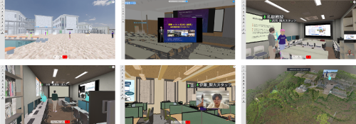
National Institute for Land and Infrastructure Management, MLIT
"VR NILIM (Kokusoken)"
"VR NILIM (Kokusoken)" that reproduces the whole space of NILIM Asahi office
Utsunomiya City
"Utsunomiya Digital City Experience Project"
With the aim of providing effective social studies education even when travel is limited, 3D models of major facilities to be visited on social studies tours, such as the area around Utsunomiya Station, including the LRT, fire stations, water purification plants, and incineration plants, were reproduced on the web.
Sakurai Kogyo Co., Ltd.
"Virtual Office"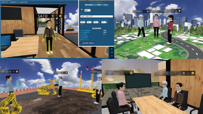
Companywide initiative from a need to facilitate communication in design work. Building up "Sakurai Collabo", a unique virtual office based on F8VPS
![]()
VR-Cloud® is a consensus building solution which uses 3D and VR on a cloud server. With only internet access environment, even thin client would be able to operate the VR space by web browser.
Product Info
VR-Cloud® Ver.6 Collaboration
A full-featured VR cloud system that enables advanced communication between clients and VR. Implementation of shared content management. 3D bulletin board, landscape evaluation, conference support for multiple users. Equipped with annotation and photo functions.
▲Content viewer
▲3D icons
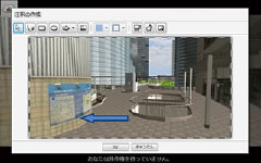
▲Annotation function
▲Landscape evaluation