|
|
The 14th 3D VR Simulation Contest on Cloud |
|
 |
| |
| Results Annoucement |
|
2015/11/24 |
|
|
|
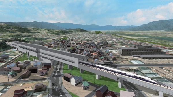
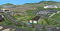
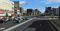
Kitsuki City jokamachi (castle town) future proposals
Kitsuki City, Oita Prefecture |
|
|
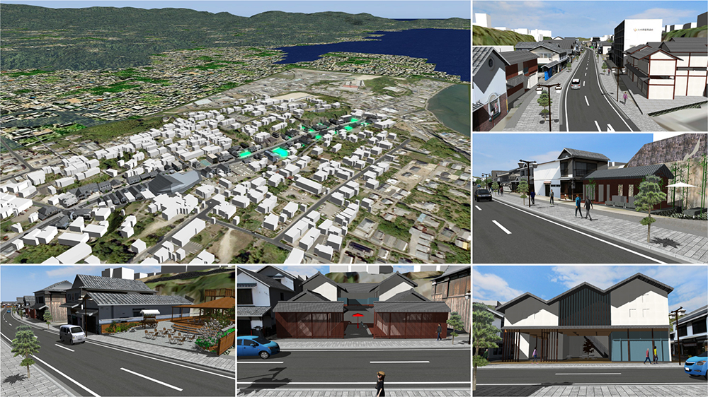
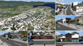
| The site of Virtual Architecture Competition -Build Live Japan 2015-. Here,
designers and local municipality scramble to turn the Kitsuki castle town
into a 3D VR replica via point clouds to allow quick comparison and easy
snapping of proposed 3D building models into the virtual world. All proposals
are openly available to citizens to review, to evaluate that the finished
project could truly blend in and stay consistent to the ancient architectures
of the castle town. The attempt was well received and demonstrates how
VR can indeed help in urban planning. |
 |
|
|
 |
|
This project data can actually be divided into 12 sub-proposals, with 12
different camera positions assigned to each of them. Executing the script
allows viewers to view the entire project area and perform before &
after analysis to contrast the changes that have been done. |
|
|
|
|
|
VR for Rebuilding Ruins
Tho.La.Consulting |
|
|
The Korokan Ruins discovered in 1988 which is located in the center of Fukuoka, Japan and the research is still being conducted.
Whether this important historic sites should be rebuild or not was discussed between voters and this VR data was created as a basic data for explanation to relevant people.
Also it was helpful enough as the education material which allows people to know the situation of the time and have been used on the museum and government's HP as an advertisement for citizens too. |
 |
|
|
|
|
The animated script "presentation" takes viewers to the Korokan site, with explanations of its history, function, and the proposed image upon restoration. In the history portion of the script, the interiors adapt to different design styles of Japanese historic eras. Candle night-lightings of the restored site is also an exciting sight. |
|
|
|
|
|
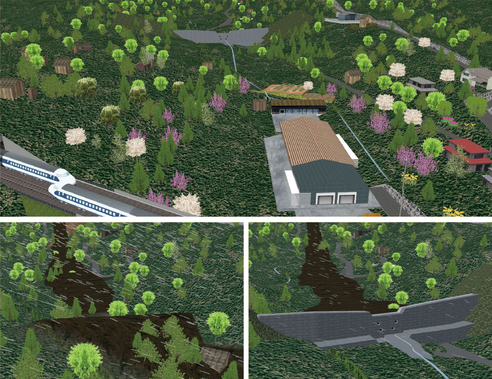
Using VR to Communicate to the Locals Over Debris Avalanche Countermeasure
Mitsui Consultants, Kansai Branch |
|
|
| Debris avalanche and mountain slides are becoming more common in Japan recently, and there has been high hopes of using soil check dams to counter these. However, due to its rarity, a wide adoption cannot be achieved without effective communication with the local residents. This VR data visualizes the risk maps of debris avalanche under different conditions and severity, while demonstrating the effectiveness of check dams in a comprehensible way. |
 |
|
|
|
|
By playing back the script "Present", followed by "Incident",
viewers will be introduced with the current environment situation and witness
the steep angles at the proposal site, as well as experience how severe
the hazards will be in case of a debris-flow. In the script "Improvement
3", different types of land check dams have been constructed at the
same site for landscape evaluation. The script "With Explanation"
offers further explanations. |
|
|
|
|
|
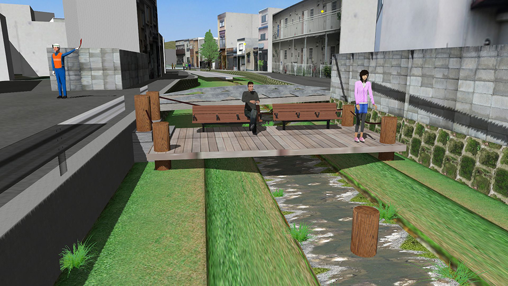
Repair simulation in Higashi Takase river 2015
Fushimi Technical High School in Kyoto |
|
|
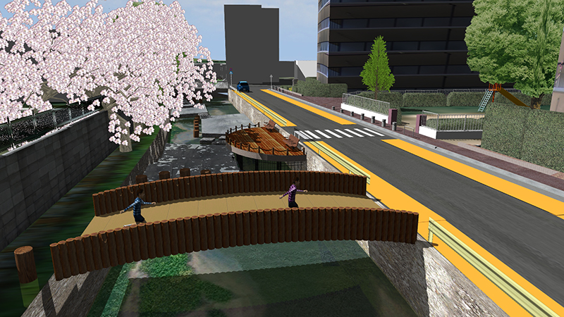
We have explored an improvement in the surrounding environment of Higashi Takase river as a region's issue.
This year, we investigated about the river flow rate from river cross-section and about available heavy machines from the width of surrounding roads.
The environment where the enough river cross-section is secured and people around the area get together is proposed in this data. |
 |
|
|
|
|
Takasegawa is a beautiful river canal in Kyoto, but the downstream section,
Higashi (east) Takasegawa, is nowhere as eye-pleasing nor safe as its upstream
cousin. Upon executing the animation script "East-Takasegawa Proposal
2015", an improvement proposal, with hazard mitigation and ease of
construction taken into account, will be introduced to the viewers. Detailed
engineering considerations such as fluid flow and road width for heavy
machineries have all been considered to ensure a realistic evaluation of
project feasibility. Some interesting parts of this proposal include a
riverside promenade, which requires a double-layered structure, and the
use of decks and scaffolds to ensure ease of construction. |
|
|
|
|
 |
Honorable Judge's Award Regional Construction Award
Mr. Hiroo Kasagi (NPO Chiiki Zukuri Kobo) |
|
Dream Zone - Creating the Town You Want to Return! - Awaji City Yumebutai
Sustainable Park, Compact City Project
Awaji City Hall, Hyogo Prefecture |
|
|
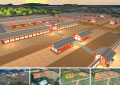
This is a virtual replica of the nature-rich Akashi Kaikyo National Government Park, the home of Japan Flora in 2000 - with proposals to further adapt them for commercial activities.
The making and theme of the various parts of the Park is demonstrated in a comprehensible way with the intent of attracting more attentions from corporates for business developments.
The vision aims at creating a convenient but compact city, with health care, offices, and residential zones divided clearly inside the 3D data. |
 |
|
|
|
|
The camera position "Overview 01" and "Overview 02"
gives an overview of the entire project site area and the Sustainable Park.
By executing the Project Overview script, viewers will be taken on a virtual
tour inside the park and will be introduced with the numerous proposed
zones, including; "Commercial-Residential Zone", "Welfare
Zone, "Residential Zone", and "Business Park Zone".
The most satisfying part of the 3D environment is looking down at the entire
town from the hills facing the Osaka-Bay. |
|
|
|
|
|
Honorable Judge's Award Safety Award
Mr. Tatsuoki Inagaki (Pave & Road How-To Way Technology Association) |
|
Smart Technology Concept Simulation
Mitsumi Electric Co., Ltd. |
|
|
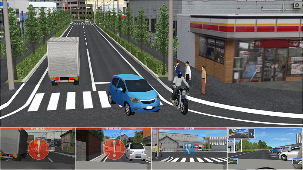
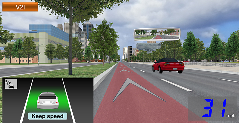
This is a VR data used in a driving simulator for the demonstration and promotion of on-board wide angle camera and Miracast system in cars.
The wide angle camera is used to help navigating through various blind spots or high-risk areas, such as parking lots, residential areas, wide avenues, and expressways. It is also capable of parking assists and has sensors to warn of suddenly approaching hazards and protruding of parking lines. Furthermore, the Miracast feature allows the streaming of smartphone contents into the vehicle navigation monitor to gain the latest versions of maps or the operation of various smartphone apps. |
 |
|
|
|
|
By executing the scenario "Cloud Ver. Demo", a vivid, overview
image of smart onboard technologies will be shown. For example, blind spot
clearing features that helps drivers check for suddenly approaching pedestrian
or cars at very narrow places such as freeway interchanges or parking lots.
|
|
|
|
|
|
Honorable Judge's Award Design Award
Mr. Fumio Seki (Nihon University) |
|
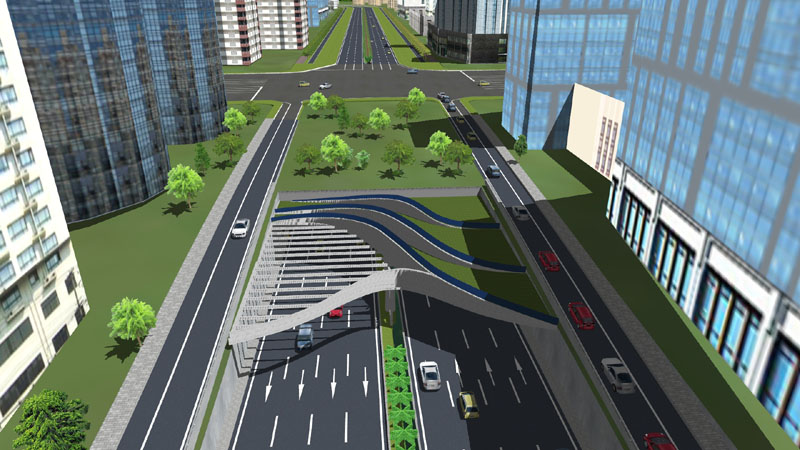
Underground rapid road design project
RIOH |
|
|
| A part of Southern China region is recreated inside a 8-DOF driving simulator,
to test a tunnel project. The driving simulator is used to examine the
various types of driving behaviours at the tunnel's entrance and exit.
By basing on the behavioural findings and vehicle log data, engineers evaluate
the effectiveness of the underground expressway and safety, and devise
countermeasures for any problems found and perform advices for the contractors. |
 |
|
|
|
|
Execute the script "underground highway, takes users onto a quick
tour to explore the underground highway. Finally, the script "Entrance
Shadow"showcases the unique entrance design with a simulation of its
shadows. |
|
|
|
|
|
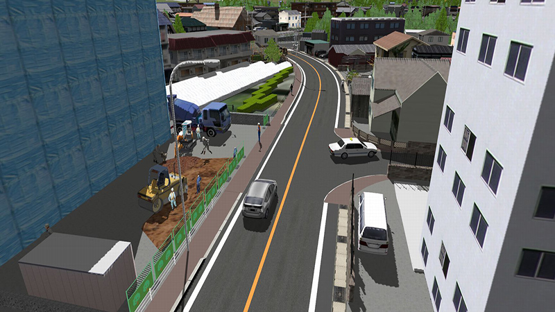
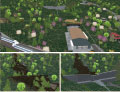
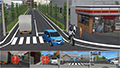
The landscape VR simulation of The Town with Fishing Port
SOZOTECH |
|
|
This is the landscape VR simulation of surrounding area of "The town with fishing port".
Creating the landscape VR simulation makes it easier to check the school roads and road conditions etc. Furthermore, it is possible to change the weather and time, which will be able to be used for extracting improvement points for the future road maintenance. |
 |
|
|
|
|
Playing the Script1 script will introduce the viewer an overview of the town through bird's eye view and first-person perspective. The saved camera position include a fishing port, roadway intersections, and the construction site. |
|
|
|
|
|
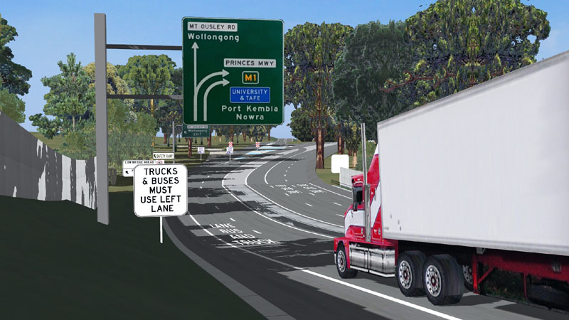
CITI (Cooperative Intelligent Transport Initiative) project
Transport for NSW, Centre for Road Safety In collaboration with University
of Wollongong, SMART Infrastructure Facility (scenarios) |
|
|
A 3D virtual model of 11km of the Princes Motorway, south of Sydney, with scenarios - both for demonstration and interactive driving- to show how CIT systems will work.
On the descent into Wollongong, trucks are limited to 40kph and must stay in the left two lanes, while other traffic is going 80kph. The scenarios show a truck cab that displays warning messages for the several kinds of situations. |
 |
|
|
|
|
By following the saved camera positions consecutively, viewers can see
the current road condition of the Princes Motorway and its various interchanges
and intersections. Upon executing the MtOusley-Intro scenario, various
safety warning messages regarding leading cars and intersection hazards,
allowing users to have a glimpse of cutting-edge road safety research. |
|
|
|
|
|
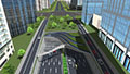
Nagoya City Street VR Simulation -Shaping a Green Mobility Society -
Nagoya University |
|
|
This is the VR data used for a large driving simulator used in researches in the Nagoya University to achieve a distant dream - achieving a "Green Mobility Society" without compromising on safety.
The street roads between Nagoya Interchange and Nagoya University was precisely recreated, and have numerous scenarios tailor made for different researches. This is the data used inside the World's first 4K 3D 6-DOF CAVE simulator for maximum VR simulation immersion. |
 |
|
|
|
|
A 7 km journey from the Nagoya Freeway Interchange to Nagoya University
has been made. In the animated script, viewers will be introduced a 3D
replica of the urban environment surrounding the roads, which include the
Kamiyashiro-Junction, Higashiyama-Park, and a portion of Nagoya University.
What is interesting about this project data is the precise recreation of
the Yamate-Greenroad, a complex road section that is known to have numerous
upslope, downslope, and curves on a straight road - an excellent (virtual)
testbed. |
|
|
|
|
|
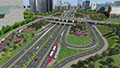
Design of the cloverleaf interchange
Qingdao Municipal Engineering Design Institute, China |
|
|
The government of Qingdao, China uses UC-win/Road to evaluate various designs
of a proposed clover-shaped highway interchange. By coordinating with VISSIM
analysis results, the complicated neighbouring traffic conditions is recreated
and the traffic signals fully optimized to ensure maximum evaluation accuracy.
|
 |
|
|
|
|
Following the camera positions in numerical order, various large-scale
objects such as multi-level interchange and neighbouring buildings that
can be viewed from many different angles. Executing the animated script
"Multi-Level Interchange" will put viewers directly onto the
roads or pedestrian bridges, allowing a more immersive sensation of the
designs. |
|
|
|
|
3DVR simulation contest using UC-win/Road. This is held every year since 2002 when UC-win/Road won the "Software
Product of the year" award. Various brilliant works have been presented
as a main event of this festival and it has brought even more excitement
with the introduction of cloud voting via VR-Cloud® since 2011. The works are represented with the script (5min) and scenarios
and evaluation and voting are performed with cloud system.
2015.10.9 Fri Deadline for works submittion
Deliverable
- VR data created via UC-win/Road (script is required to be created and the work is needed to be stored in media such as CD-ROM and DVD etc.)
- Overview of VR data (up to 150 words) and how to operate the data
Where to deliver the data
Please tell your contact person of FORUM8 staff and send it to him.
|
2015.10.16 Fri Meeting for selecting nomination works
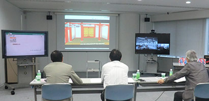 |
 |
Meeting for selecting nomination works
at Seminar Room in FORUM8 Head Office |
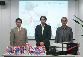
Judging Committe
Mr. Tatsuoki Inagaki, Mr. Fumio Seki and
Mr. Kasagi Hiroo from the right |
|
| 2015.11.7 Sat - 11.15 Sun Period of public voting on cloud |
2015.11.17 Tue Examining Meeting FORUM8 Tokyo head office MAP
Meeting for selecting nomination works
The judgment will be performed by 70% of public voting, 30% of voting from
judging committee based on the ranking point and ranking point for special
awards. |
 |
|
2015.11.19 Thu SHINAGAWA INTERCITY Hall
Award Ceremony of the 14th 3DVR Simulation Contest on Cloud |
| |
Guidelines for Applicants |
| Deadline for works submittion |
October 9 (Fri), 2015 |
| Deliverable |
- VR data created via UC-win/Road (script is required to be created and the work is needed to be stored in media such as CD-ROM and DVD etc.)
- Overview of VR data (up to 150 words) and how to operate the data |
| Where to deliver the data |
Please tell your contact person of FORUM8 staff and send it to him. |
| Copyright |
All contents of the awarded VR data is the copyright of each applicants.
The submitted VR data will not be distributed, but FORUM8 has a right to use the data and works, edit and reproduce the images and videos etc. and post or introduce it on website, magazines, books, newspaper etc. as a sales activity or an advertisement as a secoundary user of VR data. Please be forewarned. |
| Inquiries for the application |
Please tell your contact person of FORUM8 staff. |
Meeting for selecting
nomination works |
nomination works Nominated works will be decided on October 16 (Fri), 2015.
Meeting for selecting nomination works on October 16 (Fri), 2015 |
| |
Profile of Judging Committe |
 |
Mr. Fumio Seki
Professor of Engineering department, Hihon University
After graduating the department of science and engineering, Nihon University,
he joined Design Planning office for civil design of Taisei Corporation
and has been engaged in design etc. for road structure, river, harbor and
lecture etc.
Appointed in the current position since 2011. |
 |
Mr. Kasagi Hiroo
Representative of NPO Chiikizukuri Kobo
Director of Japan Society for Impact Assesment, part-time instructor of
Nagano University, CEO of Kizakiko Hot Spring Development Co., Ltd. Councilor
of Omachi Kita high school. Author of some books. Won the prize of Minister
for the Environment for his activity of global warming in 2005. |
 |
Mr. Tatsuoki Inagaki
Director of Pave & Road How-To Way Technology Association
Holding a post of information technology manager Road Management Technology Center and currently taking on a director of Pave & Road How-To Way Technology Association. Author of some books about pavement engineering and road engineering.
He is engaged in improvement of technology of road and pavement and promotion
of research development. |
■Grand Prix ■Semi-Grand Prix (Excellence Award)
■Special Awards [Idea Award / Essence Award] ■Judge Award
■Nominate Award
No dual recipients.
| General voting period : November 7 (Sat) - 15 (Sun), 2015 |
| For a list of nominated works, click here |
 |
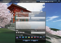
You can view, control the VR data, and vote for the works. |
| You can vote from nominated works. You can vote more than once but you
cannot change your vote once it has been submitted. |
| Please view all data and vote. |

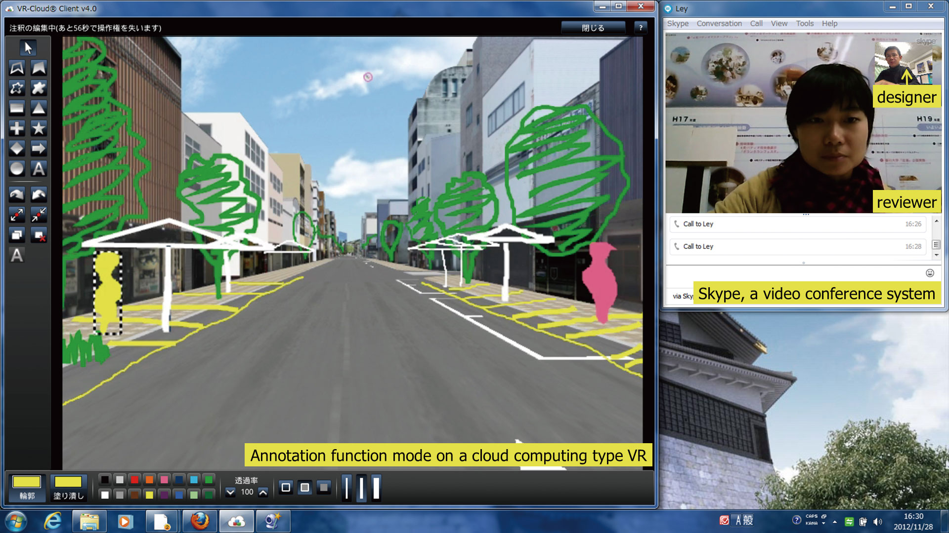
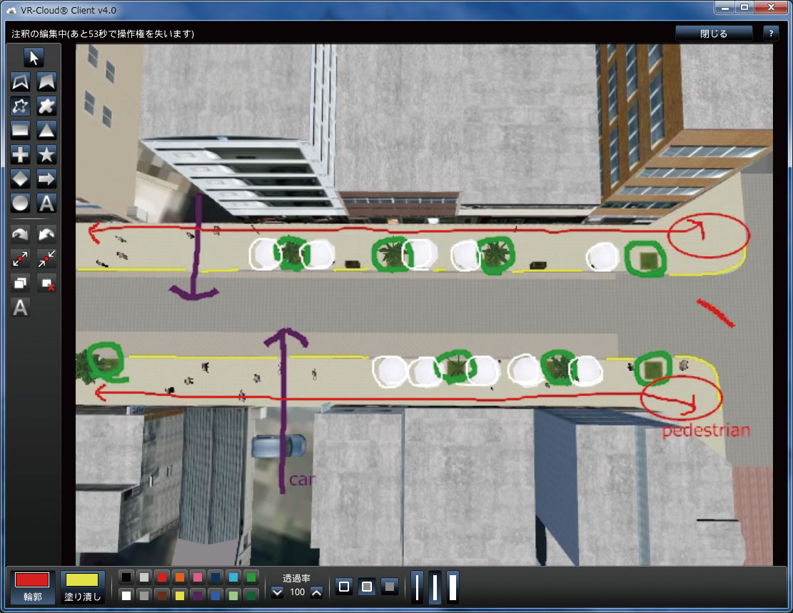
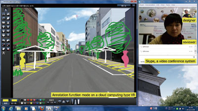
An interactive real-time VR system utilized as a tool for building wide consensus for public works and developments.
|
 
VR-Cloud® is a consensus building solution which uses 3D and VR on a cloud
server. With only internet access environment, even thin client would be
able to operate the VR space by web browser.
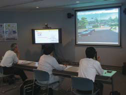
| Example of use : Laboratry of Tomohiro Fukuda of Environment and Energy
department of graduate school, Osaka University |
 |
 |
 |
 Example of Design Meeting Example of Design Meeting
- Manual input of design (Annotation function)
- Conference sceen using video conference system (Skype) |
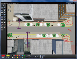
The camera position (viewpoint) can be freely changed in VR environment. |
3D bulletin board function with evaluative function for landscape |
|
| |
Introduction of the past awarded works |
|
|
|